You are here: Home > Network List > TA - USArray Transportable Network (new EarthScope stations) Stations List
> Station O20A White River City, CO, USA > Earthquake Result Viewer
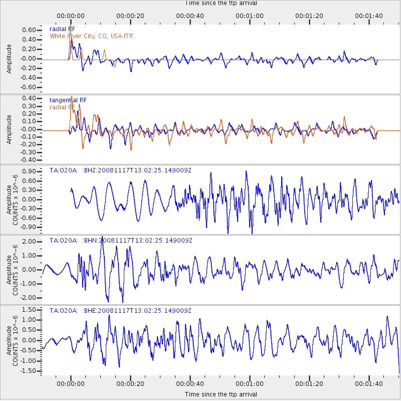
O20A White River City, CO, USA - Earthquake Result Viewer
*The percent match for this event was below the threshold and hence no stack was calculated.
| Earthquake location: |
Arctic Ocean |
| Earthquake latitude/longitude: |
79.6/-116.1 |
| Earthquake time(UTC): |
2008/11/17 (322) 12:55:22 GMT |
| Earthquake Depth: |
7.0 km |
| Earthquake Magnitude: |
5.7 MW, 5.2 MS, 5.4 MB, 5.7 MW |
| Earthquake Catalog/Contributor: |
WHDF/NEIC |
|
| Network: |
TA USArray Transportable Network (new EarthScope stations) |
| Station: |
O20A White River City, CO, USA |
| Lat/Lon: |
40.13 N/108.24 W |
| Elevation: |
1915 m |
|
| Distance: |
39.8 deg |
| Az: |
170.618 deg |
| Baz: |
357.796 deg |
| Ray Param: |
$rayparam |
*The percent match for this event was below the threshold and hence was not used in the summary stack. |
|
| Radial Match: |
65.00588 % |
| Radial Bump: |
400 |
| Transverse Match: |
65.23479 % |
| Transverse Bump: |
400 |
| SOD ConfigId: |
2658 |
| Insert Time: |
2010-03-06 12:42:55.286 +0000 |
| GWidth: |
2.5 |
| Max Bumps: |
400 |
| Tol: |
0.001 |
|
Signal To Noise
| Channel | StoN | STA | LTA |
| TA:O20A: :BHN:20081117T13:02:25.149009Z | 1.971257 | 6.410702E-7 | 3.2520884E-7 |
| TA:O20A: :BHE:20081117T13:02:25.149009Z | 0.86866814 | 2.9797243E-7 | 3.4302218E-7 |
| TA:O20A: :BHZ:20081117T13:02:25.149009Z | 0.77526075 | 2.6446432E-7 | 3.4112952E-7 |
| Arrivals |
| Ps | |
| PpPs | |
| PsPs/PpSs | |


