You are here: Home > Network List > CI - Caltech Regional Seismic Network Stations List
> Station MPP McPhearson Peak > Earthquake Result Viewer
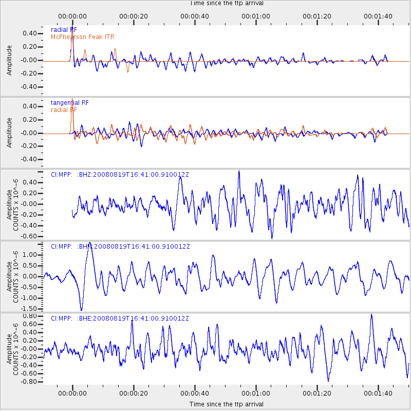
MPP McPhearson Peak - Earthquake Result Viewer
*The percent match for this event was below the threshold and hence no stack was calculated.
| Earthquake location: |
Tonga Islands |
| Earthquake latitude/longitude: |
-15.1/-173.5 |
| Earthquake time(UTC): |
2008/08/19 (232) 16:30:13 GMT |
| Earthquake Depth: |
8.0 km |
| Earthquake Magnitude: |
5.6 MB, 5.9 MS, 6.1 MW, 6.0 MW |
| Earthquake Catalog/Contributor: |
WHDF/NEIC |
|
| Network: |
CI Caltech Regional Seismic Network |
| Station: |
MPP McPhearson Peak |
| Lat/Lon: |
34.89 N/119.81 W |
| Elevation: |
1739 m |
|
| Distance: |
71.1 deg |
| Az: |
44.409 deg |
| Baz: |
235.313 deg |
| Ray Param: |
$rayparam |
*The percent match for this event was below the threshold and hence was not used in the summary stack. |
|
| Radial Match: |
74.61064 % |
| Radial Bump: |
400 |
| Transverse Match: |
62.95043 % |
| Transverse Bump: |
400 |
| SOD ConfigId: |
2504 |
| Insert Time: |
2010-02-26 02:05:04.996 +0000 |
| GWidth: |
2.5 |
| Max Bumps: |
400 |
| Tol: |
0.001 |
|
Signal To Noise
| Channel | StoN | STA | LTA |
| CI:MPP: :BHN:20080819T16:41:00.910012Z | 7.023804 | 7.244246E-7 | 1.031385E-7 |
| CI:MPP: :BHE:20080819T16:41:00.910012Z | 1.1723393 | 1.4935954E-7 | 1.2740298E-7 |
| CI:MPP: :BHZ:20080819T16:41:00.910012Z | 2.0915163 | 2.01033E-7 | 9.6118306E-8 |
| Arrivals |
| Ps | |
| PpPs | |
| PsPs/PpSs | |


