You are here: Home > Network List > CI - Caltech Regional Seismic Network Stations List
> Station MPP McPhearson Peak > Earthquake Result Viewer
MPP McPhearson Peak - Earthquake Result Viewer
*The percent match for this event was below the threshold and hence no stack was calculated.
| Earthquake location: |
Tonga Islands |
| Earthquake latitude/longitude: |
-18.4/-175.4 |
| Earthquake time(UTC): |
2008/10/22 (296) 12:55:57 GMT |
| Earthquake Depth: |
233 km |
| Earthquake Magnitude: |
5.9 MB, 6.4 MW, 6.3 MW |
| Earthquake Catalog/Contributor: |
WHDF/NEIC |
|
| Network: |
CI Caltech Regional Seismic Network |
| Station: |
MPP McPhearson Peak |
| Lat/Lon: |
34.89 N/119.81 W |
| Elevation: |
1739 m |
|
| Distance: |
74.8 deg |
| Az: |
44.628 deg |
| Baz: |
234.227 deg |
| Ray Param: |
$rayparam |
*The percent match for this event was below the threshold and hence was not used in the summary stack. |
|
| Radial Match: |
53.586483 % |
| Radial Bump: |
400 |
| Transverse Match: |
49.703465 % |
| Transverse Bump: |
400 |
| SOD ConfigId: |
2560 |
| Insert Time: |
2010-02-26 02:05:06.394 +0000 |
| GWidth: |
2.5 |
| Max Bumps: |
400 |
| Tol: |
0.001 |
|
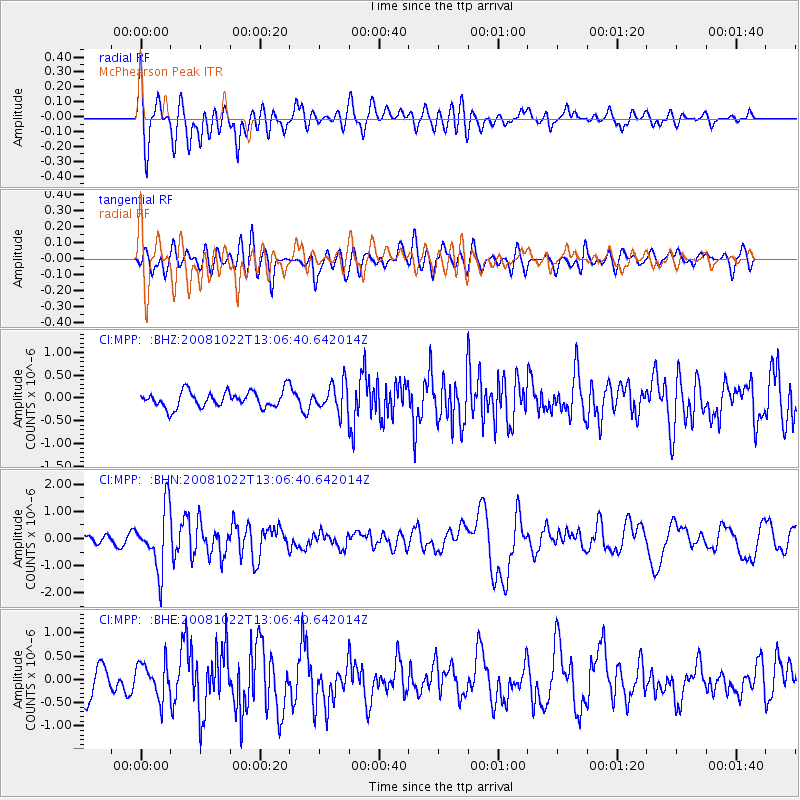
Signal To Noise
| Channel | StoN | STA | LTA |
| CI:MPP: :BHN:20081022T13:06:40.642014Z | 5.0187254 | 1.1107348E-6 | 2.2131812E-7 |
| CI:MPP: :BHE:20081022T13:06:40.642014Z | 1.2549313 | 3.8571326E-7 | 3.0735805E-7 |
| CI:MPP: :BHZ:20081022T13:06:40.642014Z | 1.7337217 | 3.089321E-7 | 1.7819013E-7 |
| Arrivals |
| Ps | |
| PpPs | |
| PsPs/PpSs | |


