You are here: Home > Network List > TA - USArray Transportable Network (new EarthScope stations) Stations List
> Station B18K Kokolik River, AK, USA > Earthquake Result Viewer
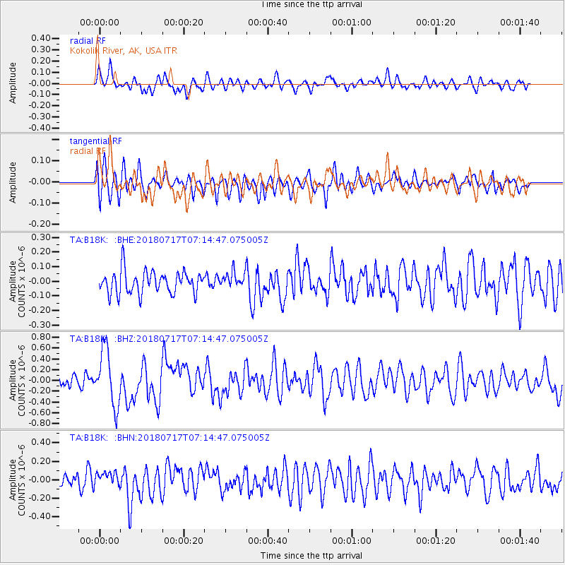
B18K Kokolik River, AK, USA - Earthquake Result Viewer
*The percent match for this event was below the threshold and hence no stack was calculated.
| Earthquake location: |
Santa Cruz Islands |
| Earthquake latitude/longitude: |
-11.7/166.3 |
| Earthquake time(UTC): |
2018/07/17 (198) 07:02:55 GMT |
| Earthquake Depth: |
60 km |
| Earthquake Magnitude: |
5.9 Mww |
| Earthquake Catalog/Contributor: |
NEIC PDE/us |
|
| Network: |
TA USArray Transportable Network (new EarthScope stations) |
| Station: |
B18K Kokolik River, AK, USA |
| Lat/Lon: |
69.36 N/161.80 W |
| Elevation: |
222 m |
|
| Distance: |
83.9 deg |
| Az: |
10.85 deg |
| Baz: |
211.34 deg |
| Ray Param: |
$rayparam |
*The percent match for this event was below the threshold and hence was not used in the summary stack. |
|
| Radial Match: |
64.39572 % |
| Radial Bump: |
400 |
| Transverse Match: |
67.363144 % |
| Transverse Bump: |
400 |
| SOD ConfigId: |
13570011 |
| Insert Time: |
2019-04-30 14:04:51.386 +0000 |
| GWidth: |
2.5 |
| Max Bumps: |
400 |
| Tol: |
0.001 |
|
Signal To Noise
| Channel | StoN | STA | LTA |
| TA:B18K: :BHZ:20180717T07:14:47.075005Z | 3.9187112 | 5.2731735E-7 | 1.3456398E-7 |
| TA:B18K: :BHN:20180717T07:14:47.075005Z | 1.0257269 | 7.3118784E-8 | 7.1284845E-8 |
| TA:B18K: :BHE:20180717T07:14:47.075005Z | 0.9032302 | 6.8849E-8 | 7.6225305E-8 |
| Arrivals |
| Ps | |
| PpPs | |
| PsPs/PpSs | |


