You are here: Home > Network List > TA - USArray Transportable Network (new EarthScope stations) Stations List
> Station C16K Lisburne Hills, AK, USA > Earthquake Result Viewer
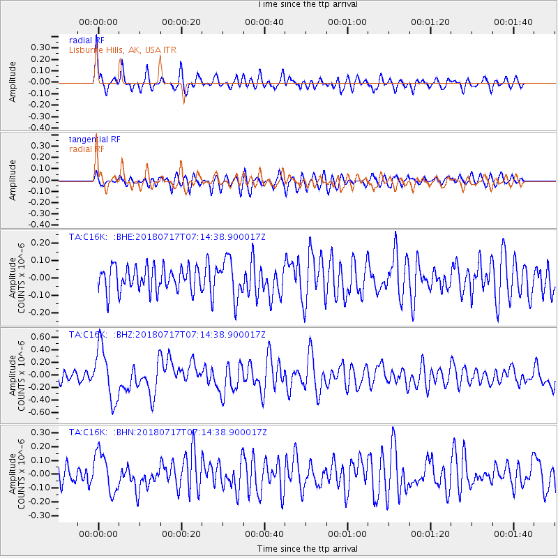
C16K Lisburne Hills, AK, USA - Earthquake Result Viewer
*The percent match for this event was below the threshold and hence no stack was calculated.
| Earthquake location: |
Santa Cruz Islands |
| Earthquake latitude/longitude: |
-11.7/166.3 |
| Earthquake time(UTC): |
2018/07/17 (198) 07:02:55 GMT |
| Earthquake Depth: |
60 km |
| Earthquake Magnitude: |
5.9 Mww |
| Earthquake Catalog/Contributor: |
NEIC PDE/us |
|
| Network: |
TA USArray Transportable Network (new EarthScope stations) |
| Station: |
C16K Lisburne Hills, AK, USA |
| Lat/Lon: |
68.27 N/165.34 W |
| Elevation: |
102 m |
|
| Distance: |
82.3 deg |
| Az: |
10.269 deg |
| Baz: |
207.97 deg |
| Ray Param: |
$rayparam |
*The percent match for this event was below the threshold and hence was not used in the summary stack. |
|
| Radial Match: |
73.63043 % |
| Radial Bump: |
400 |
| Transverse Match: |
61.032486 % |
| Transverse Bump: |
400 |
| SOD ConfigId: |
13570011 |
| Insert Time: |
2019-04-30 14:04:52.702 +0000 |
| GWidth: |
2.5 |
| Max Bumps: |
400 |
| Tol: |
0.001 |
|
Signal To Noise
| Channel | StoN | STA | LTA |
| TA:C16K: :BHZ:20180717T07:14:38.900017Z | 6.311737 | 4.3734917E-7 | 6.929141E-8 |
| TA:C16K: :BHN:20180717T07:14:38.900017Z | 1.9576492 | 1.4933688E-7 | 7.628378E-8 |
| TA:C16K: :BHE:20180717T07:14:38.900017Z | 1.6667359 | 1.14315625E-7 | 6.858652E-8 |
| Arrivals |
| Ps | |
| PpPs | |
| PsPs/PpSs | |


