You are here: Home > Network List > TA - USArray Transportable Network (new EarthScope stations) Stations List
> Station E20K Nigu River, AK, USA > Earthquake Result Viewer
E20K Nigu River, AK, USA - Earthquake Result Viewer
| Earthquake location: |
Santa Cruz Islands |
| Earthquake latitude/longitude: |
-11.7/166.3 |
| Earthquake time(UTC): |
2018/07/17 (198) 07:02:55 GMT |
| Earthquake Depth: |
60 km |
| Earthquake Magnitude: |
5.9 Mww |
| Earthquake Catalog/Contributor: |
NEIC PDE/us |
|
| Network: |
TA USArray Transportable Network (new EarthScope stations) |
| Station: |
E20K Nigu River, AK, USA |
| Lat/Lon: |
68.26 N/156.19 W |
| Elevation: |
866 m |
|
| Distance: |
84.1 deg |
| Az: |
13.175 deg |
| Baz: |
216.814 deg |
| Ray Param: |
0.04560957 |
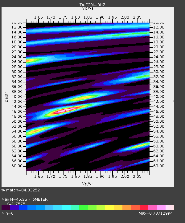
| Estimated Moho Depth: |
45.25 km |
| Estimated Crust Vp/Vs: |
1.76 |
| Assumed Crust Vp: |
6.221 km/s |
| Estimated Crust Vs: |
3.54 km/s |
| Estimated Crust Poisson's Ratio: |
0.26 |
|
| Radial Match: |
84.83252 % |
| Radial Bump: |
342 |
| Transverse Match: |
74.3253 % |
| Transverse Bump: |
400 |
| SOD ConfigId: |
13570011 |
| Insert Time: |
2019-04-30 14:05:10.746 +0000 |
| GWidth: |
2.5 |
| Max Bumps: |
400 |
| Tol: |
0.001 |
|
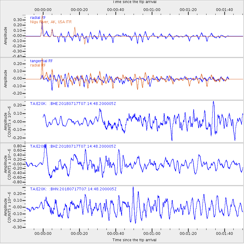
Signal To Noise
| Channel | StoN | STA | LTA |
| TA:E20K: :BHZ:20180717T07:14:48.200005Z | 9.841489 | 4.892706E-7 | 4.9715098E-8 |
| TA:E20K: :BHN:20180717T07:14:48.200005Z | 1.955999 | 6.992408E-8 | 3.5748524E-8 |
| TA:E20K: :BHE:20180717T07:14:48.200005Z | 2.128648 | 7.5328934E-8 | 3.5388158E-8 |
| Arrivals |
| Ps | 5.6 SECOND |
| PpPs | 20 SECOND |
| PsPs/PpSs | 25 SECOND |


