You are here: Home > Network List > TA - USArray Transportable Network (new EarthScope stations) Stations List
> Station E21K Killik River, AK, USA > Earthquake Result Viewer
E21K Killik River, AK, USA - Earthquake Result Viewer
| Earthquake location: |
Santa Cruz Islands |
| Earthquake latitude/longitude: |
-11.7/166.3 |
| Earthquake time(UTC): |
2018/07/17 (198) 07:02:55 GMT |
| Earthquake Depth: |
60 km |
| Earthquake Magnitude: |
5.9 Mww |
| Earthquake Catalog/Contributor: |
NEIC PDE/us |
|
| Network: |
TA USArray Transportable Network (new EarthScope stations) |
| Station: |
E21K Killik River, AK, USA |
| Lat/Lon: |
68.44 N/153.97 W |
| Elevation: |
653 m |
|
| Distance: |
84.8 deg |
| Az: |
13.714 deg |
| Baz: |
218.924 deg |
| Ray Param: |
0.045144755 |
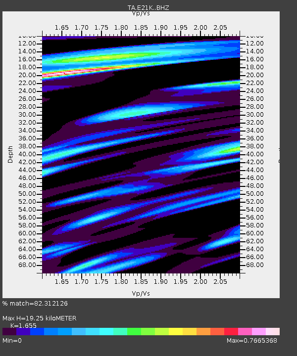
| Estimated Moho Depth: |
19.25 km |
| Estimated Crust Vp/Vs: |
1.65 |
| Assumed Crust Vp: |
6.221 km/s |
| Estimated Crust Vs: |
3.759 km/s |
| Estimated Crust Poisson's Ratio: |
0.21 |
|
| Radial Match: |
82.312126 % |
| Radial Bump: |
400 |
| Transverse Match: |
74.92598 % |
| Transverse Bump: |
400 |
| SOD ConfigId: |
13570011 |
| Insert Time: |
2019-04-30 14:05:11.521 +0000 |
| GWidth: |
2.5 |
| Max Bumps: |
400 |
| Tol: |
0.001 |
|

Signal To Noise
| Channel | StoN | STA | LTA |
| TA:E21K: :BHZ:20180717T07:14:51.475029Z | 9.185756 | 4.925985E-7 | 5.362634E-8 |
| TA:E21K: :BHN:20180717T07:14:51.475029Z | 3.300948 | 1.1751995E-7 | 3.560188E-8 |
| TA:E21K: :BHE:20180717T07:14:51.475029Z | 2.772712 | 9.574033E-8 | 3.4529492E-8 |
| Arrivals |
| Ps | 2.1 SECOND |
| PpPs | 8.0 SECOND |
| PsPs/PpSs | 10 SECOND |


