You are here: Home > Network List > TA - USArray Transportable Network (new EarthScope stations) Stations List
> Station F22K John River, AK, USA > Earthquake Result Viewer
F22K John River, AK, USA - Earthquake Result Viewer
| Earthquake location: |
Santa Cruz Islands |
| Earthquake latitude/longitude: |
-11.7/166.3 |
| Earthquake time(UTC): |
2018/07/17 (198) 07:02:55 GMT |
| Earthquake Depth: |
60 km |
| Earthquake Magnitude: |
5.9 Mww |
| Earthquake Catalog/Contributor: |
NEIC PDE/us |
|
| Network: |
TA USArray Transportable Network (new EarthScope stations) |
| Station: |
F22K John River, AK, USA |
| Lat/Lon: |
67.51 N/152.18 W |
| Elevation: |
546 m |
|
| Distance: |
84.5 deg |
| Az: |
14.839 deg |
| Baz: |
220.69 deg |
| Ray Param: |
0.045351066 |
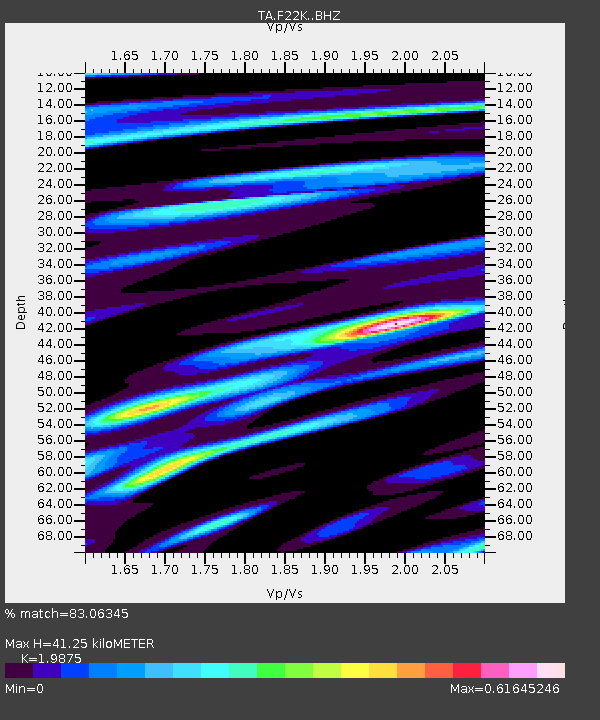
| Estimated Moho Depth: |
41.25 km |
| Estimated Crust Vp/Vs: |
1.99 |
| Assumed Crust Vp: |
6.455 km/s |
| Estimated Crust Vs: |
3.248 km/s |
| Estimated Crust Poisson's Ratio: |
0.33 |
|
| Radial Match: |
83.06345 % |
| Radial Bump: |
391 |
| Transverse Match: |
75.46667 % |
| Transverse Bump: |
400 |
| SOD ConfigId: |
13570011 |
| Insert Time: |
2019-04-30 14:05:23.456 +0000 |
| GWidth: |
2.5 |
| Max Bumps: |
400 |
| Tol: |
0.001 |
|

Signal To Noise
| Channel | StoN | STA | LTA |
| TA:F22K: :BHZ:20180717T07:14:50.025017Z | 6.861769 | 3.77903E-7 | 5.50737E-8 |
| TA:F22K: :BHN:20180717T07:14:50.025017Z | 4.488254 | 1.0292249E-7 | 2.2931523E-8 |
| TA:F22K: :BHE:20180717T07:14:50.025017Z | 2.8078578 | 8.071384E-8 | 2.8745701E-8 |
| Arrivals |
| Ps | 6.5 SECOND |
| PpPs | 19 SECOND |
| PsPs/PpSs | 25 SECOND |


