You are here: Home > Network List > TA - USArray Transportable Network (new EarthScope stations) Stations List
> Station G19K Purcell Mountains, AK, USA > Earthquake Result Viewer
G19K Purcell Mountains, AK, USA - Earthquake Result Viewer
| Earthquake location: |
Santa Cruz Islands |
| Earthquake latitude/longitude: |
-11.7/166.3 |
| Earthquake time(UTC): |
2018/07/17 (198) 07:02:55 GMT |
| Earthquake Depth: |
60 km |
| Earthquake Magnitude: |
5.9 Mww |
| Earthquake Catalog/Contributor: |
NEIC PDE/us |
|
| Network: |
TA USArray Transportable Network (new EarthScope stations) |
| Station: |
G19K Purcell Mountains, AK, USA |
| Lat/Lon: |
66.14 N/157.09 W |
| Elevation: |
391 m |
|
| Distance: |
82.2 deg |
| Az: |
14.163 deg |
| Baz: |
216.104 deg |
| Ray Param: |
0.046949252 |
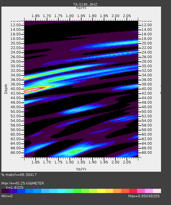
| Estimated Moho Depth: |
40.25 km |
| Estimated Crust Vp/Vs: |
1.63 |
| Assumed Crust Vp: |
6.577 km/s |
| Estimated Crust Vs: |
4.029 km/s |
| Estimated Crust Poisson's Ratio: |
0.20 |
|
| Radial Match: |
89.38417 % |
| Radial Bump: |
320 |
| Transverse Match: |
69.974434 % |
| Transverse Bump: |
400 |
| SOD ConfigId: |
13570011 |
| Insert Time: |
2019-04-30 14:05:31.193 +0000 |
| GWidth: |
2.5 |
| Max Bumps: |
400 |
| Tol: |
0.001 |
|

Signal To Noise
| Channel | StoN | STA | LTA |
| TA:G19K: :BHZ:20180717T07:14:38.325005Z | 8.684309 | 4.869009E-7 | 5.606674E-8 |
| TA:G19K: :BHN:20180717T07:14:38.325005Z | 3.2694945 | 1.3782453E-7 | 4.2154692E-8 |
| TA:G19K: :BHE:20180717T07:14:38.325005Z | 2.695502 | 1.1743819E-7 | 4.3568207E-8 |
| Arrivals |
| Ps | 4.0 SECOND |
| PpPs | 16 SECOND |
| PsPs/PpSs | 20 SECOND |


