You are here: Home > Network List > TA - USArray Transportable Network (new EarthScope stations) Stations List
> Station M18K Stony River, AK, USA > Earthquake Result Viewer
M18K Stony River, AK, USA - Earthquake Result Viewer
| Earthquake location: |
Santa Cruz Islands |
| Earthquake latitude/longitude: |
-11.7/166.3 |
| Earthquake time(UTC): |
2018/07/17 (198) 07:02:55 GMT |
| Earthquake Depth: |
60 km |
| Earthquake Magnitude: |
5.9 Mww |
| Earthquake Catalog/Contributor: |
NEIC PDE/us |
|
| Network: |
TA USArray Transportable Network (new EarthScope stations) |
| Station: |
M18K Stony River, AK, USA |
| Lat/Lon: |
61.49 N/155.82 W |
| Elevation: |
289 m |
|
| Distance: |
78.8 deg |
| Az: |
17.463 deg |
| Baz: |
217.782 deg |
| Ray Param: |
0.049287796 |
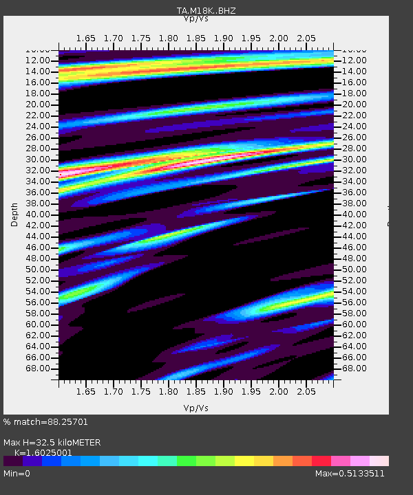
| Estimated Moho Depth: |
32.5 km |
| Estimated Crust Vp/Vs: |
1.60 |
| Assumed Crust Vp: |
6.566 km/s |
| Estimated Crust Vs: |
4.097 km/s |
| Estimated Crust Poisson's Ratio: |
0.18 |
|
| Radial Match: |
88.25701 % |
| Radial Bump: |
400 |
| Transverse Match: |
73.43624 % |
| Transverse Bump: |
400 |
| SOD ConfigId: |
13570011 |
| Insert Time: |
2019-04-30 14:06:25.922 +0000 |
| GWidth: |
2.5 |
| Max Bumps: |
400 |
| Tol: |
0.001 |
|

Signal To Noise
| Channel | StoN | STA | LTA |
| TA:M18K: :BHZ:20180717T07:14:20.124993Z | 8.20615 | 5.5301786E-7 | 6.739066E-8 |
| TA:M18K: :BHN:20180717T07:14:20.124993Z | 1.9339173 | 1.2544756E-7 | 6.486707E-8 |
| TA:M18K: :BHE:20180717T07:14:20.124993Z | 3.2812002 | 1.3905984E-7 | 4.238078E-8 |
| Arrivals |
| Ps | 3.1 SECOND |
| PpPs | 12 SECOND |
| PsPs/PpSs | 16 SECOND |


