You are here: Home > Network List > TA - USArray Transportable Network (new EarthScope stations) Stations List
> Station MSTX Muleshoe, TX, USA > Earthquake Result Viewer
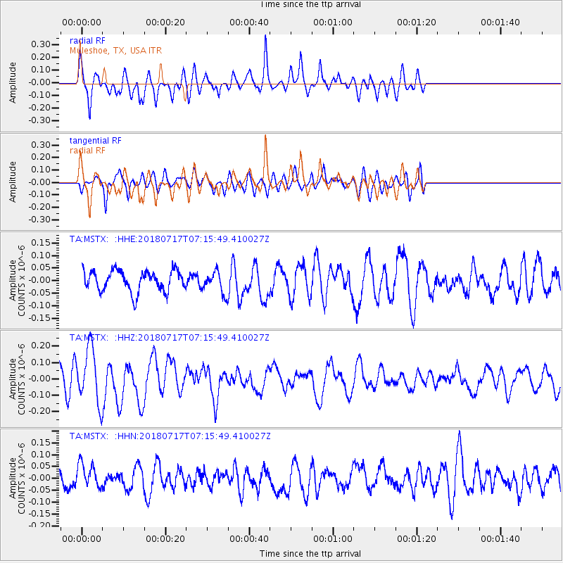
MSTX Muleshoe, TX, USA - Earthquake Result Viewer
*The percent match for this event was below the threshold and hence no stack was calculated.
| Earthquake location: |
Santa Cruz Islands |
| Earthquake latitude/longitude: |
-11.7/166.3 |
| Earthquake time(UTC): |
2018/07/17 (198) 07:02:55 GMT |
| Earthquake Depth: |
60 km |
| Earthquake Magnitude: |
5.9 Mww |
| Earthquake Catalog/Contributor: |
NEIC PDE/us |
|
| Network: |
TA USArray Transportable Network (new EarthScope stations) |
| Station: |
MSTX Muleshoe, TX, USA |
| Lat/Lon: |
33.97 N/102.77 W |
| Elevation: |
1167 m |
|
| Distance: |
97.2 deg |
| Az: |
56.878 deg |
| Baz: |
260.789 deg |
| Ray Param: |
$rayparam |
*The percent match for this event was below the threshold and hence was not used in the summary stack. |
|
| Radial Match: |
68.620575 % |
| Radial Bump: |
400 |
| Transverse Match: |
49.866795 % |
| Transverse Bump: |
400 |
| SOD ConfigId: |
13570011 |
| Insert Time: |
2019-04-30 14:06:35.921 +0000 |
| GWidth: |
2.5 |
| Max Bumps: |
400 |
| Tol: |
0.001 |
|
Signal To Noise
| Channel | StoN | STA | LTA |
| TA:MSTX: :HHZ:20180717T07:15:49.410027Z | 2.4568934 | 1.7202855E-7 | 7.001873E-8 |
| TA:MSTX: :HHN:20180717T07:15:49.410027Z | 1.0295348 | 5.1750842E-8 | 5.026624E-8 |
| TA:MSTX: :HHE:20180717T07:15:49.410027Z | 1.1610548 | 4.729885E-8 | 4.0737827E-8 |
| Arrivals |
| Ps | |
| PpPs | |
| PsPs/PpSs | |


