You are here: Home > Network List > TA - USArray Transportable Network (new EarthScope stations) Stations List
> Station N23A Red Feather Lakes, CO, USA > Earthquake Result Viewer
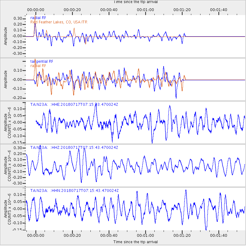
N23A Red Feather Lakes, CO, USA - Earthquake Result Viewer
*The percent match for this event was below the threshold and hence no stack was calculated.
| Earthquake location: |
Santa Cruz Islands |
| Earthquake latitude/longitude: |
-11.7/166.3 |
| Earthquake time(UTC): |
2018/07/17 (198) 07:02:55 GMT |
| Earthquake Depth: |
60 km |
| Earthquake Magnitude: |
5.9 Mww |
| Earthquake Catalog/Contributor: |
NEIC PDE/us |
|
| Network: |
TA USArray Transportable Network (new EarthScope stations) |
| Station: |
N23A Red Feather Lakes, CO, USA |
| Lat/Lon: |
40.89 N/105.94 W |
| Elevation: |
2458 m |
|
| Distance: |
95.8 deg |
| Az: |
49.592 deg |
| Baz: |
259.692 deg |
| Ray Param: |
$rayparam |
*The percent match for this event was below the threshold and hence was not used in the summary stack. |
|
| Radial Match: |
56.63489 % |
| Radial Bump: |
400 |
| Transverse Match: |
59.404324 % |
| Transverse Bump: |
375 |
| SOD ConfigId: |
13570011 |
| Insert Time: |
2019-04-30 14:06:41.767 +0000 |
| GWidth: |
2.5 |
| Max Bumps: |
400 |
| Tol: |
0.001 |
|
Signal To Noise
| Channel | StoN | STA | LTA |
| TA:N23A: :HHZ:20180717T07:15:43.470024Z | 2.700527 | 1.651547E-7 | 6.115648E-8 |
| TA:N23A: :HHN:20180717T07:15:43.470024Z | 1.4253064 | 5.7109553E-8 | 4.0068265E-8 |
| TA:N23A: :HHE:20180717T07:15:43.470024Z | 1.8372157 | 6.107376E-8 | 3.3242564E-8 |
| Arrivals |
| Ps | |
| PpPs | |
| PsPs/PpSs | |


