You are here: Home > Network List > TA - USArray Transportable Network (new EarthScope stations) Stations List
> Station O28M Mount Upton, YT, CAN > Earthquake Result Viewer
O28M Mount Upton, YT, CAN - Earthquake Result Viewer

| Earthquake location: |
Santa Cruz Islands |
| Earthquake latitude/longitude: |
-11.7/166.3 |
| Earthquake time(UTC): |
2018/07/17 (198) 07:02:55 GMT |
| Earthquake Depth: |
60 km |
| Earthquake Magnitude: |
5.9 Mww |
| Earthquake Catalog/Contributor: |
NEIC PDE/us |
|
| Network: |
TA USArray Transportable Network (new EarthScope stations) |
| Station: |
O28M Mount Upton, YT, CAN |
| Lat/Lon: |
60.77 N/140.19 W |
| Elevation: |
2622 m |
|
| Distance: |
83.6 deg |
| Az: |
23.382 deg |
| Baz: |
232.377 deg |
| Ray Param: |
0.04592633 |
| Estimated Moho Depth: |
60.0 km |
| Estimated Crust Vp/Vs: |
1.77 |
| Assumed Crust Vp: |
6.566 km/s |
| Estimated Crust Vs: |
3.704 km/s |
| Estimated Crust Poisson's Ratio: |
0.27 |
|
| Radial Match: |
83.68449 % |
| Radial Bump: |
400 |
| Transverse Match: |
80.52287 % |
| Transverse Bump: |
400 |
| SOD ConfigId: |
13570011 |
| Insert Time: |
2019-04-30 14:06:51.385 +0000 |
| GWidth: |
2.5 |
| Max Bumps: |
400 |
| Tol: |
0.001 |
|
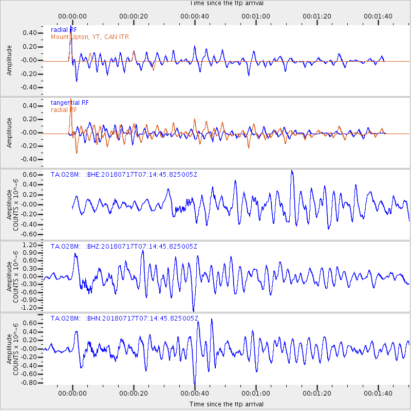
Signal To Noise
| Channel | StoN | STA | LTA |
| TA:O28M: :BHZ:20180717T07:14:45.825005Z | 4.9083166 | 4.2839997E-7 | 8.7280426E-8 |
| TA:O28M: :BHN:20180717T07:14:45.825005Z | 4.130413 | 2.478823E-7 | 6.0013924E-8 |
| TA:O28M: :BHE:20180717T07:14:45.825005Z | 2.065397 | 1.6959137E-7 | 8.211078E-8 |
| Arrivals |
| Ps | 7.2 SECOND |
| PpPs | 25 SECOND |
| PsPs/PpSs | 32 SECOND |


