You are here: Home > Network List > TA - USArray Transportable Network (new EarthScope stations) Stations List
> Station 526A Mary Lane Ranch, Marfa, TX, USA > Earthquake Result Viewer
526A Mary Lane Ranch, Marfa, TX, USA - Earthquake Result Viewer
| Earthquake location: |
Easter Island Region |
| Earthquake latitude/longitude: |
-28.5/-112.8 |
| Earthquake time(UTC): |
2008/08/19 (232) 10:58:00 GMT |
| Earthquake Depth: |
9.0 km |
| Earthquake Magnitude: |
5.5 MB, 5.3 MS, 5.7 MW, 5.7 MW |
| Earthquake Catalog/Contributor: |
WHDF/NEIC |
|
| Network: |
TA USArray Transportable Network (new EarthScope stations) |
| Station: |
526A Mary Lane Ranch, Marfa, TX, USA |
| Lat/Lon: |
30.06 N/104.09 W |
| Elevation: |
1405 m |
|
| Distance: |
58.9 deg |
| Az: |
8.865 deg |
| Baz: |
188.997 deg |
| Ray Param: |
0.062562235 |
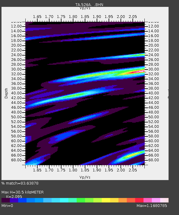
| Estimated Moho Depth: |
30.5 km |
| Estimated Crust Vp/Vs: |
2.10 |
| Assumed Crust Vp: |
6.361 km/s |
| Estimated Crust Vs: |
3.036 km/s |
| Estimated Crust Poisson's Ratio: |
0.35 |
|
| Radial Match: |
83.63878 % |
| Radial Bump: |
397 |
| Transverse Match: |
67.21544 % |
| Transverse Bump: |
400 |
| SOD ConfigId: |
2504 |
| Insert Time: |
2010-03-06 12:45:01.002 +0000 |
| GWidth: |
2.5 |
| Max Bumps: |
400 |
| Tol: |
0.001 |
|
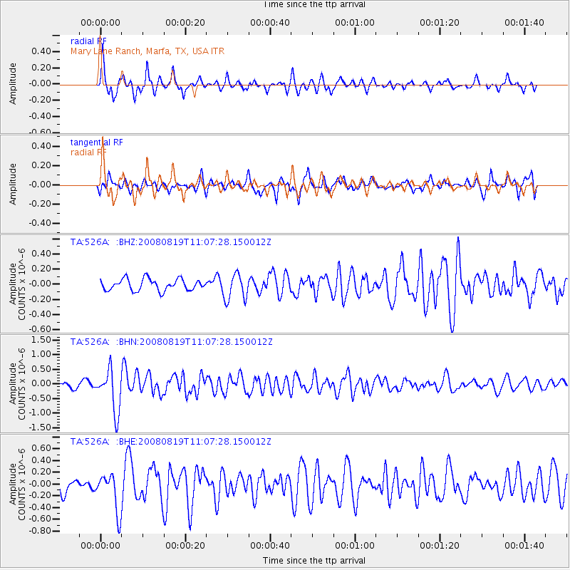
Signal To Noise
| Channel | StoN | STA | LTA |
| TA:526A: :BHN:20080819T11:07:28.150012Z | 6.613037 | 7.376775E-7 | 1.1154898E-7 |
| TA:526A: :BHE:20080819T11:07:28.150012Z | 2.4847968 | 3.3579832E-7 | 1.3514115E-7 |
| TA:526A: :BHZ:20080819T11:07:28.150012Z | 2.3162262 | 1.745397E-7 | 7.5355196E-8 |
| Arrivals |
| Ps | 5.5 SECOND |
| PpPs | 14 SECOND |
| PsPs/PpSs | 20 SECOND |


