You are here: Home > Network List > UW - Pacific Northwest Regional Seismic Network Stations List
> Station LCCR Mulino, OR, USA > Earthquake Result Viewer
LCCR Mulino, OR, USA - Earthquake Result Viewer
*The percent match for this event was below the threshold and hence no stack was calculated.
| Earthquake location: |
Santa Cruz Islands |
| Earthquake latitude/longitude: |
-11.7/166.3 |
| Earthquake time(UTC): |
2018/07/17 (198) 07:02:55 GMT |
| Earthquake Depth: |
60 km |
| Earthquake Magnitude: |
5.9 Mww |
| Earthquake Catalog/Contributor: |
NEIC PDE/us |
|
| Network: |
UW Pacific Northwest Regional Seismic Network |
| Station: |
LCCR Mulino, OR, USA |
| Lat/Lon: |
45.21 N/122.48 W |
| Elevation: |
273 m |
|
| Distance: |
85.4 deg |
| Az: |
42.174 deg |
| Baz: |
248.475 deg |
| Ray Param: |
$rayparam |
*The percent match for this event was below the threshold and hence was not used in the summary stack. |
|
| Radial Match: |
66.037544 % |
| Radial Bump: |
400 |
| Transverse Match: |
53.10893 % |
| Transverse Bump: |
400 |
| SOD ConfigId: |
13570011 |
| Insert Time: |
2019-04-30 14:07:57.566 +0000 |
| GWidth: |
2.5 |
| Max Bumps: |
400 |
| Tol: |
0.001 |
|
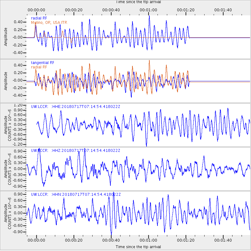
Signal To Noise
| Channel | StoN | STA | LTA |
| UW:LCCR: :HHZ:20180717T07:14:54.418022Z | 3.7411952 | 6.2504927E-7 | 1.6707209E-7 |
| UW:LCCR: :HHN:20180717T07:14:54.418022Z | 0.7003388 | 2.1441429E-7 | 3.0615794E-7 |
| UW:LCCR: :HHE:20180717T07:14:54.418022Z | 0.71013534 | 2.5022354E-7 | 3.5236033E-7 |
| Arrivals |
| Ps | |
| PpPs | |
| PsPs/PpSs | |


