You are here: Home > Network List > CI - Caltech Regional Seismic Network Stations List
> Station MPP McPhearson Peak > Earthquake Result Viewer
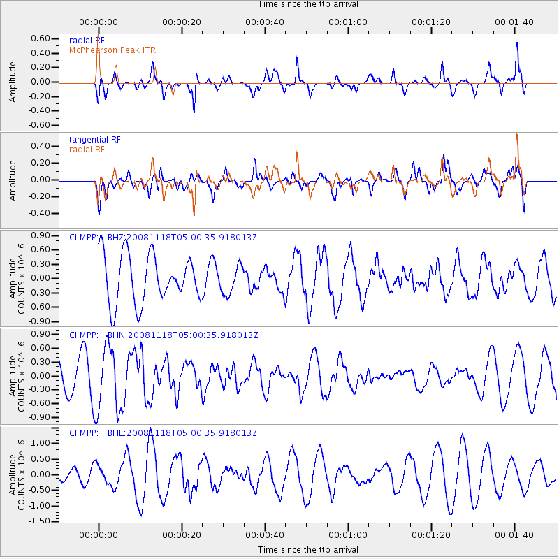
MPP McPhearson Peak - Earthquake Result Viewer
*The percent match for this event was below the threshold and hence no stack was calculated.
| Earthquake location: |
Arctic Ocean |
| Earthquake latitude/longitude: |
79.7/-115.5 |
| Earthquake time(UTC): |
2008/11/18 (323) 04:52:51 GMT |
| Earthquake Depth: |
10 km |
| Earthquake Magnitude: |
5.6 ML, 5.3 MB |
| Earthquake Catalog/Contributor: |
WHDF/NEIC |
|
| Network: |
CI Caltech Regional Seismic Network |
| Station: |
MPP McPhearson Peak |
| Lat/Lon: |
34.89 N/119.81 W |
| Elevation: |
1739 m |
|
| Distance: |
45.0 deg |
| Az: |
185.071 deg |
| Baz: |
1.104 deg |
| Ray Param: |
$rayparam |
*The percent match for this event was below the threshold and hence was not used in the summary stack. |
|
| Radial Match: |
59.35957 % |
| Radial Bump: |
400 |
| Transverse Match: |
65.94486 % |
| Transverse Bump: |
400 |
| SOD ConfigId: |
2658 |
| Insert Time: |
2010-02-26 02:05:11.474 +0000 |
| GWidth: |
2.5 |
| Max Bumps: |
400 |
| Tol: |
0.001 |
|
Signal To Noise
| Channel | StoN | STA | LTA |
| CI:MPP: :BHN:20081118T05:00:35.918013Z | 2.9056394 | 7.0934453E-7 | 2.4412682E-7 |
| CI:MPP: :BHE:20081118T05:00:35.918013Z | 0.9476951 | 3.3141177E-7 | 3.4970296E-7 |
| CI:MPP: :BHZ:20081118T05:00:35.918013Z | 0.5775206 | 2.8991045E-7 | 5.019915E-7 |
| Arrivals |
| Ps | |
| PpPs | |
| PsPs/PpSs | |


