You are here: Home > Network List > TA - USArray Transportable Network (new EarthScope stations) Stations List
> Station 526A Mary Lane Ranch, Marfa, TX, USA > Earthquake Result Viewer
526A Mary Lane Ranch, Marfa, TX, USA - Earthquake Result Viewer
| Earthquake location: |
Santa Cruz Islands |
| Earthquake latitude/longitude: |
-12.4/166.1 |
| Earthquake time(UTC): |
2009/10/07 (280) 22:50:15 GMT |
| Earthquake Depth: |
21 km |
| Earthquake Magnitude: |
5.8 MB |
| Earthquake Catalog/Contributor: |
WHDF/NEIC |
|
| Network: |
TA USArray Transportable Network (new EarthScope stations) |
| Station: |
526A Mary Lane Ranch, Marfa, TX, USA |
| Lat/Lon: |
30.06 N/104.09 W |
| Elevation: |
1405 m |
|
| Distance: |
95.9 deg |
| Az: |
60.649 deg |
| Baz: |
259.203 deg |
| Ray Param: |
0.040639937 |
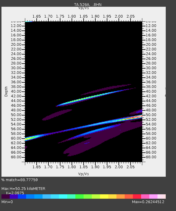
| Estimated Moho Depth: |
50.25 km |
| Estimated Crust Vp/Vs: |
2.10 |
| Assumed Crust Vp: |
6.361 km/s |
| Estimated Crust Vs: |
3.032 km/s |
| Estimated Crust Poisson's Ratio: |
0.35 |
|
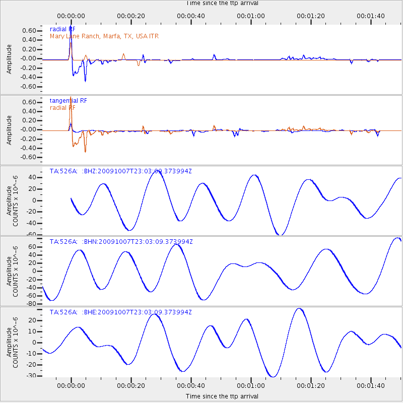
| Radial Match: |
88.77759 % |
| Radial Bump: |
329 |
| Transverse Match: |
49.76342 % |
| Transverse Bump: |
374 |
| SOD ConfigId: |
2622 |
| Insert Time: |
2010-03-06 12:45:43.129 +0000 |
| GWidth: |
2.5 |
| Max Bumps: |
400 |
| Tol: |
0.001 |
|
Signal To Noise
| Channel | StoN | STA | LTA |
| TA:526A: :BHN:20091007T23:03:09.373994Z | 1.2335533 | 4.37391E-5 | 3.545781E-5 |
| TA:526A: :BHE:20091007T23:03:09.373994Z | 1.9376732 | 1.4241566E-5 | 7.3498286E-6 |
| TA:526A: :BHZ:20091007T23:03:09.373994Z | 1.6180521 | 3.938507E-5 | 2.434104E-5 |
| Arrivals |
| Ps | 8.8 SECOND |
| PpPs | 24 SECOND |
| PsPs/PpSs | 33 SECOND |


