You are here: Home > Network List > TA - USArray Transportable Network (new EarthScope stations) Stations List
> Station 526A Mary Lane Ranch, Marfa, TX, USA > Earthquake Result Viewer
526A Mary Lane Ranch, Marfa, TX, USA - Earthquake Result Viewer
| Earthquake location: |
Kermadec Islands Region |
| Earthquake latitude/longitude: |
-31.5/-178.8 |
| Earthquake time(UTC): |
2009/05/16 (136) 00:53:52 GMT |
| Earthquake Depth: |
55 km |
| Earthquake Magnitude: |
6.1 MB, 6.5 MW, 6.3 MW |
| Earthquake Catalog/Contributor: |
WHDF/NEIC |
|
| Network: |
TA USArray Transportable Network (new EarthScope stations) |
| Station: |
526A Mary Lane Ranch, Marfa, TX, USA |
| Lat/Lon: |
30.06 N/104.09 W |
| Elevation: |
1405 m |
|
| Distance: |
93.7 deg |
| Az: |
56.924 deg |
| Baz: |
235.635 deg |
| Ray Param: |
0.04119132 |
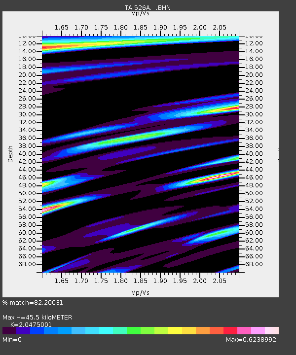
| Estimated Moho Depth: |
45.5 km |
| Estimated Crust Vp/Vs: |
2.05 |
| Assumed Crust Vp: |
6.361 km/s |
| Estimated Crust Vs: |
3.107 km/s |
| Estimated Crust Poisson's Ratio: |
0.34 |
|
| Radial Match: |
82.20031 % |
| Radial Bump: |
400 |
| Transverse Match: |
78.32824 % |
| Transverse Bump: |
400 |
| SOD ConfigId: |
2760 |
| Insert Time: |
2010-03-06 12:46:12.955 +0000 |
| GWidth: |
2.5 |
| Max Bumps: |
400 |
| Tol: |
0.001 |
|
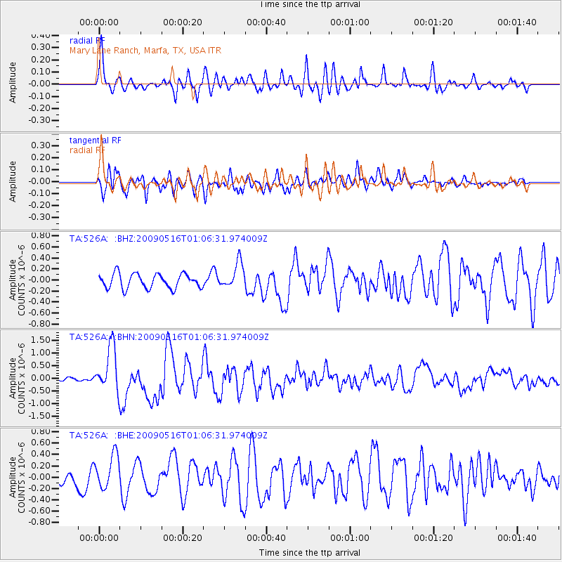
Signal To Noise
| Channel | StoN | STA | LTA |
| TA:526A: :BHN:20090516T01:06:31.974009Z | 9.050688 | 9.272531E-7 | 1.0245112E-7 |
| TA:526A: :BHE:20090516T01:06:31.974009Z | 3.0731287 | 3.048342E-7 | 9.9193436E-8 |
| TA:526A: :BHZ:20090516T01:06:31.974009Z | 1.8597577 | 2.4387938E-7 | 1.3113504E-7 |
| Arrivals |
| Ps | 7.6 SECOND |
| PpPs | 21 SECOND |
| PsPs/PpSs | 29 SECOND |


