You are here: Home > Network List > CI - Caltech Regional Seismic Network Stations List
> Station MPP McPhearson Peak > Earthquake Result Viewer
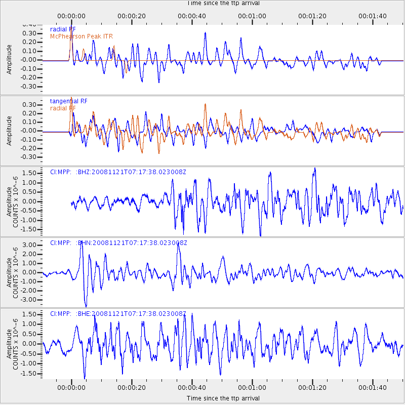
MPP McPhearson Peak - Earthquake Result Viewer
*The percent match for this event was below the threshold and hence no stack was calculated.
| Earthquake location: |
Solomon Islands |
| Earthquake latitude/longitude: |
-8.9/159.6 |
| Earthquake time(UTC): |
2008/11/21 (326) 07:05:34 GMT |
| Earthquake Depth: |
118 km |
| Earthquake Magnitude: |
6.0 MB, 6.1 MW, 6.0 MW |
| Earthquake Catalog/Contributor: |
WHDF/NEIC |
|
| Network: |
CI Caltech Regional Seismic Network |
| Station: |
MPP McPhearson Peak |
| Lat/Lon: |
34.89 N/119.81 W |
| Elevation: |
1739 m |
|
| Distance: |
87.5 deg |
| Az: |
54.282 deg |
| Baz: |
257.362 deg |
| Ray Param: |
$rayparam |
*The percent match for this event was below the threshold and hence was not used in the summary stack. |
|
| Radial Match: |
72.94188 % |
| Radial Bump: |
400 |
| Transverse Match: |
75.700226 % |
| Transverse Bump: |
400 |
| SOD ConfigId: |
2658 |
| Insert Time: |
2010-02-26 02:05:12.836 +0000 |
| GWidth: |
2.5 |
| Max Bumps: |
400 |
| Tol: |
0.001 |
|
Signal To Noise
| Channel | StoN | STA | LTA |
| CI:MPP: :BHN:20081121T07:17:38.023008Z | 5.2050633 | 1.7710728E-6 | 3.402596E-7 |
| CI:MPP: :BHE:20081121T07:17:38.023008Z | 2.271823 | 6.896274E-7 | 3.0355685E-7 |
| CI:MPP: :BHZ:20081121T07:17:38.023008Z | 2.6673434 | 5.760754E-7 | 2.1597349E-7 |
| Arrivals |
| Ps | |
| PpPs | |
| PsPs/PpSs | |


