You are here: Home > Network List > TA - USArray Transportable Network (new EarthScope stations) Stations List
> Station 526A Mary Lane Ranch, Marfa, TX, USA > Earthquake Result Viewer
526A Mary Lane Ranch, Marfa, TX, USA - Earthquake Result Viewer
| Earthquake location: |
Andreanof Islands, Aleutian Is. |
| Earthquake latitude/longitude: |
51.9/-177.5 |
| Earthquake time(UTC): |
2008/05/02 (123) 01:33:37 GMT |
| Earthquake Depth: |
14 km |
| Earthquake Magnitude: |
6.3 MB, 6.8 MS, 6.6 MW, 6.6 MW |
| Earthquake Catalog/Contributor: |
WHDF/NEIC |
|
| Network: |
TA USArray Transportable Network (new EarthScope stations) |
| Station: |
526A Mary Lane Ranch, Marfa, TX, USA |
| Lat/Lon: |
30.06 N/104.09 W |
| Elevation: |
1405 m |
|
| Distance: |
57.0 deg |
| Az: |
82.108 deg |
| Baz: |
314.888 deg |
| Ray Param: |
0.06374643 |
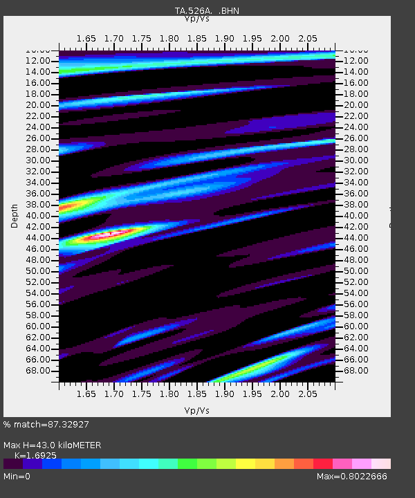
| Estimated Moho Depth: |
43.0 km |
| Estimated Crust Vp/Vs: |
1.69 |
| Assumed Crust Vp: |
6.361 km/s |
| Estimated Crust Vs: |
3.758 km/s |
| Estimated Crust Poisson's Ratio: |
0.23 |
|
| Radial Match: |
87.32927 % |
| Radial Bump: |
400 |
| Transverse Match: |
78.3064 % |
| Transverse Bump: |
400 |
| SOD ConfigId: |
2504 |
| Insert Time: |
2010-03-06 12:46:22.603 +0000 |
| GWidth: |
2.5 |
| Max Bumps: |
400 |
| Tol: |
0.001 |
|

Signal To Noise
| Channel | StoN | STA | LTA |
| TA:526A: :BHN:20080502T01:42:51.450022Z | 9.426231 | 1.36114E-6 | 1.4439918E-7 |
| TA:526A: :BHE:20080502T01:42:51.450022Z | 2.7439823 | 3.8868018E-7 | 1.416482E-7 |
| TA:526A: :BHZ:20080502T01:42:51.450022Z | 1.0398271 | 2.881981E-7 | 2.7715964E-7 |
| Arrivals |
| Ps | 4.9 SECOND |
| PpPs | 17 SECOND |
| PsPs/PpSs | 22 SECOND |


