You are here: Home > Network List > CI - Caltech Regional Seismic Network Stations List
> Station MPP McPhearson Peak > Earthquake Result Viewer
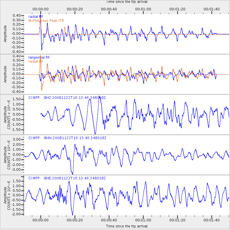
MPP McPhearson Peak - Earthquake Result Viewer
*The percent match for this event was below the threshold and hence no stack was calculated.
| Earthquake location: |
Southeast Of Loyalty Islands |
| Earthquake latitude/longitude: |
-22.5/171.2 |
| Earthquake time(UTC): |
2008/11/22 (327) 16:01:39 GMT |
| Earthquake Depth: |
57 km |
| Earthquake Magnitude: |
5.7 MB, 6.4 MW, 6.4 MW |
| Earthquake Catalog/Contributor: |
WHDF/NEIC |
|
| Network: |
CI Caltech Regional Seismic Network |
| Station: |
MPP McPhearson Peak |
| Lat/Lon: |
34.89 N/119.81 W |
| Elevation: |
1739 m |
|
| Distance: |
86.8 deg |
| Az: |
50.227 deg |
| Baz: |
239.824 deg |
| Ray Param: |
$rayparam |
*The percent match for this event was below the threshold and hence was not used in the summary stack. |
|
| Radial Match: |
63.829075 % |
| Radial Bump: |
400 |
| Transverse Match: |
54.61204 % |
| Transverse Bump: |
400 |
| SOD ConfigId: |
2658 |
| Insert Time: |
2010-02-26 02:05:15.186 +0000 |
| GWidth: |
2.5 |
| Max Bumps: |
400 |
| Tol: |
0.001 |
|
Signal To Noise
| Channel | StoN | STA | LTA |
| CI:MPP: :BHN:20081122T16:13:46.348018Z | 2.4047623 | 7.144499E-7 | 2.9709796E-7 |
| CI:MPP: :BHE:20081122T16:13:46.348018Z | 1.1304024 | 5.223908E-7 | 4.6212816E-7 |
| CI:MPP: :BHZ:20081122T16:13:46.348018Z | 2.4962103 | 1.2439594E-6 | 4.9833926E-7 |
| Arrivals |
| Ps | |
| PpPs | |
| PsPs/PpSs | |


