You are here: Home > Network List > CI - Caltech Regional Seismic Network Stations List
> Station MPP McPhearson Peak > Earthquake Result Viewer
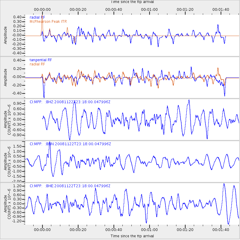
MPP McPhearson Peak - Earthquake Result Viewer
*The percent match for this event was below the threshold and hence no stack was calculated.
| Earthquake location: |
Southeast Of Easter Island |
| Earthquake latitude/longitude: |
-37.2/-95.1 |
| Earthquake time(UTC): |
2008/11/22 (327) 23:06:47 GMT |
| Earthquake Depth: |
10 km |
| Earthquake Magnitude: |
5.6 MB, 5.3 MS, 5.7 MW, 5.7 MW |
| Earthquake Catalog/Contributor: |
WHDF/NEIC |
|
| Network: |
CI Caltech Regional Seismic Network |
| Station: |
MPP McPhearson Peak |
| Lat/Lon: |
34.89 N/119.81 W |
| Elevation: |
1739 m |
|
| Distance: |
75.4 deg |
| Az: |
339.165 deg |
| Baz: |
159.801 deg |
| Ray Param: |
$rayparam |
*The percent match for this event was below the threshold and hence was not used in the summary stack. |
|
| Radial Match: |
71.109856 % |
| Radial Bump: |
400 |
| Transverse Match: |
64.25851 % |
| Transverse Bump: |
400 |
| SOD ConfigId: |
2658 |
| Insert Time: |
2010-02-26 02:05:16.534 +0000 |
| GWidth: |
2.5 |
| Max Bumps: |
400 |
| Tol: |
0.001 |
|
Signal To Noise
| Channel | StoN | STA | LTA |
| CI:MPP: :BHN:20081122T23:18:00.047996Z | 1.9229794 | 8.526098E-7 | 4.4337958E-7 |
| CI:MPP: :BHE:20081122T23:18:00.047996Z | 1.2768992 | 3.490211E-7 | 2.7333488E-7 |
| CI:MPP: :BHZ:20081122T23:18:00.047996Z | 1.0148593 | 5.0930674E-7 | 5.0184957E-7 |
| Arrivals |
| Ps | |
| PpPs | |
| PsPs/PpSs | |


