You are here: Home > Network List > TA - USArray Transportable Network (new EarthScope stations) Stations List
> Station R11B Troy Canyon, Currant, NV, USA > Earthquake Result Viewer
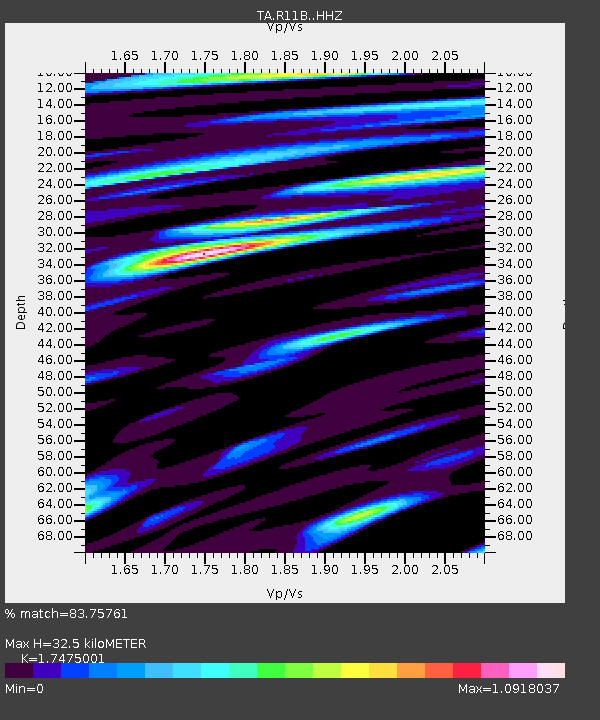
R11B Troy Canyon, Currant, NV, USA - Earthquake Result Viewer
| Earthquake location: |
Alaska Peninsula |
| Earthquake latitude/longitude: |
54.4/-160.7 |
| Earthquake time(UTC): |
2018/07/18 (199) 19:06:03 GMT |
| Earthquake Depth: |
28 km |
| Earthquake Magnitude: |
5.6 Mww |
| Earthquake Catalog/Contributor: |
NEIC PDE/us |
|
| Network: |
TA USArray Transportable Network (new EarthScope stations) |
| Station: |
R11B Troy Canyon, Currant, NV, USA |
| Lat/Lon: |
38.35 N/115.59 W |
| Elevation: |
1767 m |
|
| Distance: |
34.4 deg |
| Az: |
99.047 deg |
| Baz: |
312.745 deg |
| Ray Param: |
0.0777408 |
| Estimated Moho Depth: |
32.5 km |
| Estimated Crust Vp/Vs: |
1.75 |
| Assumed Crust Vp: |
6.276 km/s |
| Estimated Crust Vs: |
3.591 km/s |
| Estimated Crust Poisson's Ratio: |
0.26 |
|
| Radial Match: |
83.75761 % |
| Radial Bump: |
375 |
| Transverse Match: |
66.316864 % |
| Transverse Bump: |
400 |
| SOD ConfigId: |
13570011 |
| Insert Time: |
2019-04-30 14:17:14.179 +0000 |
| GWidth: |
2.5 |
| Max Bumps: |
400 |
| Tol: |
0.001 |
|

Signal To Noise
| Channel | StoN | STA | LTA |
| TA:R11B: :HHZ:20180718T19:12:17.669991Z | 1.3666345 | 4.6193936E-8 | 3.3801236E-8 |
| TA:R11B: :HHN:20180718T19:12:17.669991Z | 1.2216676 | 3.8038092E-8 | 3.1136203E-8 |
| TA:R11B: :HHE:20180718T19:12:17.669991Z | 1.4162636 | 4.8789712E-8 | 3.44496E-8 |
| Arrivals |
| Ps | 4.2 SECOND |
| PpPs | 13 SECOND |
| PsPs/PpSs | 17 SECOND |


