You are here: Home > Network List > AK - Alaska Regional Network Stations List
> Station GLI Glacier Island > Earthquake Result Viewer
GLI Glacier Island - Earthquake Result Viewer
| Earthquake location: |
Oaxaca, Mexico |
| Earthquake latitude/longitude: |
17.8/-97.8 |
| Earthquake time(UTC): |
2018/07/19 (200) 13:31:53 GMT |
| Earthquake Depth: |
55 km |
| Earthquake Magnitude: |
5.7 Mww |
| Earthquake Catalog/Contributor: |
NEIC PDE/us |
|
| Network: |
AK Alaska Regional Network |
| Station: |
GLI Glacier Island |
| Lat/Lon: |
60.88 N/147.09 W |
| Elevation: |
430 m |
|
| Distance: |
55.3 deg |
| Az: |
333.191 deg |
| Baz: |
118.547 deg |
| Ray Param: |
0.06472918 |
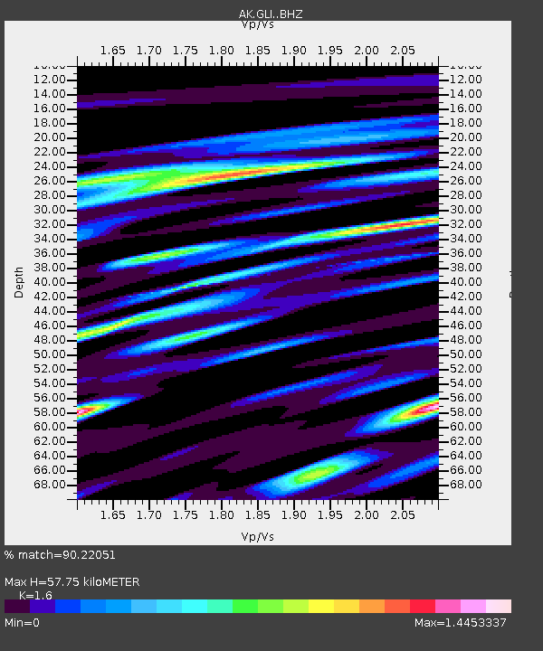
| Estimated Moho Depth: |
57.75 km |
| Estimated Crust Vp/Vs: |
1.60 |
| Assumed Crust Vp: |
6.566 km/s |
| Estimated Crust Vs: |
4.104 km/s |
| Estimated Crust Poisson's Ratio: |
0.18 |
|
| Radial Match: |
90.22051 % |
| Radial Bump: |
400 |
| Transverse Match: |
84.99094 % |
| Transverse Bump: |
400 |
| SOD ConfigId: |
13570011 |
| Insert Time: |
2019-04-30 14:19:47.983 +0000 |
| GWidth: |
2.5 |
| Max Bumps: |
400 |
| Tol: |
0.001 |
|

Signal To Noise
| Channel | StoN | STA | LTA |
| AK:GLI: :BHZ:20180719T13:40:51.147021Z | 17.477432 | 1.2826022E-6 | 7.338619E-8 |
| AK:GLI: :BHN:20180719T13:40:51.147021Z | 3.6650608 | 3.7596058E-7 | 1.02579634E-7 |
| AK:GLI: :BHE:20180719T13:40:51.147021Z | 6.3595977 | 5.4533217E-7 | 8.5749484E-8 |
| Arrivals |
| Ps | 5.6 SECOND |
| PpPs | 22 SECOND |
| PsPs/PpSs | 27 SECOND |


