You are here: Home > Network List > CI - Caltech Regional Seismic Network Stations List
> Station MPP McPhearson Peak > Earthquake Result Viewer
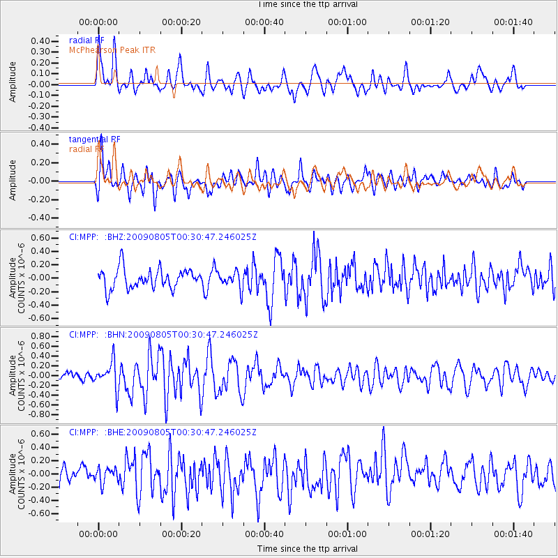
MPP McPhearson Peak - Earthquake Result Viewer
*The percent match for this event was below the threshold and hence no stack was calculated.
| Earthquake location: |
Southwestern Ryukyu Isl., Japan |
| Earthquake latitude/longitude: |
24.2/125.1 |
| Earthquake time(UTC): |
2009/08/05 (217) 00:17:58 GMT |
| Earthquake Depth: |
25 km |
| Earthquake Magnitude: |
5.9 MB, 5.9 MS, 6.2 MW, 6.1 MW |
| Earthquake Catalog/Contributor: |
WHDF/NEIC |
|
| Network: |
CI Caltech Regional Seismic Network |
| Station: |
MPP McPhearson Peak |
| Lat/Lon: |
34.89 N/119.81 W |
| Elevation: |
1739 m |
|
| Distance: |
94.9 deg |
| Az: |
48.352 deg |
| Baz: |
303.919 deg |
| Ray Param: |
$rayparam |
*The percent match for this event was below the threshold and hence was not used in the summary stack. |
|
| Radial Match: |
57.579063 % |
| Radial Bump: |
400 |
| Transverse Match: |
72.27471 % |
| Transverse Bump: |
400 |
| SOD ConfigId: |
2622 |
| Insert Time: |
2010-02-26 02:05:17.864 +0000 |
| GWidth: |
2.5 |
| Max Bumps: |
400 |
| Tol: |
0.001 |
|
Signal To Noise
| Channel | StoN | STA | LTA |
| CI:MPP: :BHN:20090805T00:30:47.246025Z | 1.8888534 | 2.8179224E-7 | 1.4918693E-7 |
| CI:MPP: :BHE:20090805T00:30:47.246025Z | 0.80784804 | 1.2131838E-7 | 1.5017476E-7 |
| CI:MPP: :BHZ:20090805T00:30:47.246025Z | 0.8375661 | 1.225392E-7 | 1.4630392E-7 |
| Arrivals |
| Ps | |
| PpPs | |
| PsPs/PpSs | |


