You are here: Home > Network List > TA - USArray Transportable Network (new EarthScope stations) Stations List
> Station 526A Mary Lane Ranch, Marfa, TX, USA > Earthquake Result Viewer
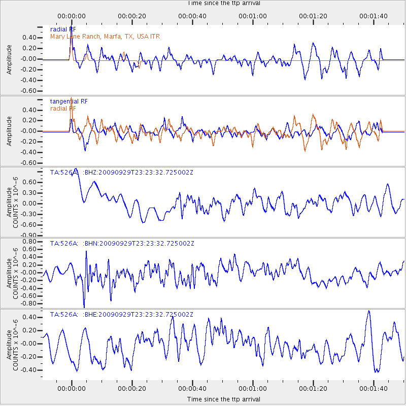
526A Mary Lane Ranch, Marfa, TX, USA - Earthquake Result Viewer
*The percent match for this event was below the threshold and hence no stack was calculated.
| Earthquake location: |
Tonga Islands |
| Earthquake latitude/longitude: |
-15.6/-173.4 |
| Earthquake time(UTC): |
2009/09/29 (272) 23:11:51 GMT |
| Earthquake Depth: |
10 km |
| Earthquake Magnitude: |
5.5 MB |
| Earthquake Catalog/Contributor: |
WHDF/NEIC |
|
| Network: |
TA USArray Transportable Network (new EarthScope stations) |
| Station: |
526A Mary Lane Ranch, Marfa, TX, USA |
| Lat/Lon: |
30.06 N/104.09 W |
| Elevation: |
1405 m |
|
| Distance: |
80.7 deg |
| Az: |
55.263 deg |
| Baz: |
245.979 deg |
| Ray Param: |
$rayparam |
*The percent match for this event was below the threshold and hence was not used in the summary stack. |
|
| Radial Match: |
65.45006 % |
| Radial Bump: |
400 |
| Transverse Match: |
56.83427 % |
| Transverse Bump: |
400 |
| SOD ConfigId: |
2622 |
| Insert Time: |
2010-03-06 12:47:25.092 +0000 |
| GWidth: |
2.5 |
| Max Bumps: |
400 |
| Tol: |
0.001 |
|
Signal To Noise
| Channel | StoN | STA | LTA |
| TA:526A: :BHN:20090929T23:23:32.725002Z | 1.4357725 | 3.5490413E-7 | 2.4718688E-7 |
| TA:526A: :BHE:20090929T23:23:32.725002Z | 1.5146478 | 3.0868455E-7 | 2.0379954E-7 |
| TA:526A: :BHZ:20090929T23:23:32.725002Z | 1.2759122 | 4.7195314E-7 | 3.6989468E-7 |
| Arrivals |
| Ps | |
| PpPs | |
| PsPs/PpSs | |


