You are here: Home > Network List > TA - USArray Transportable Network (new EarthScope stations) Stations List
> Station 526A Mary Lane Ranch, Marfa, TX, USA > Earthquake Result Viewer
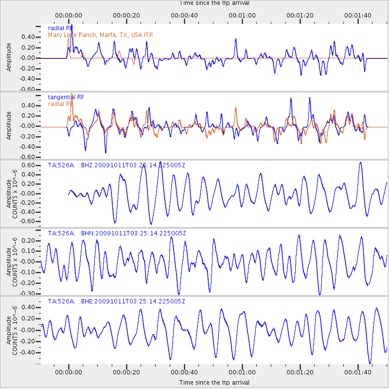
526A Mary Lane Ranch, Marfa, TX, USA - Earthquake Result Viewer
*The percent match for this event was below the threshold and hence no stack was calculated.
| Earthquake location: |
Southeast Of Loyalty Islands |
| Earthquake latitude/longitude: |
-22.0/170.2 |
| Earthquake time(UTC): |
2009/10/11 (284) 03:12:13 GMT |
| Earthquake Depth: |
10 km |
| Earthquake Magnitude: |
5.7 MB, 5.5 MS, 6.0 MW, 5.9 MW |
| Earthquake Catalog/Contributor: |
WHDF/NEIC |
|
| Network: |
TA USArray Transportable Network (new EarthScope stations) |
| Station: |
526A Mary Lane Ranch, Marfa, TX, USA |
| Lat/Lon: |
30.06 N/104.09 W |
| Elevation: |
1405 m |
|
| Distance: |
97.2 deg |
| Az: |
60.607 deg |
| Baz: |
248.857 deg |
| Ray Param: |
$rayparam |
*The percent match for this event was below the threshold and hence was not used in the summary stack. |
|
| Radial Match: |
47.412594 % |
| Radial Bump: |
387 |
| Transverse Match: |
40.481503 % |
| Transverse Bump: |
250 |
| SOD ConfigId: |
2622 |
| Insert Time: |
2010-03-06 12:47:37.471 +0000 |
| GWidth: |
2.5 |
| Max Bumps: |
400 |
| Tol: |
0.001 |
|
Signal To Noise
| Channel | StoN | STA | LTA |
| TA:526A: :BHN:20091011T03:25:14.225005Z | 0.6073235 | 1.2885886E-7 | 2.1217498E-7 |
| TA:526A: :BHE:20091011T03:25:14.225005Z | 1.0993031 | 1.9988455E-7 | 1.8182841E-7 |
| TA:526A: :BHZ:20091011T03:25:14.225005Z | 1.9458716 | 4.124536E-7 | 2.1196344E-7 |
| Arrivals |
| Ps | |
| PpPs | |
| PsPs/PpSs | |


