You are here: Home > Network List > AV - Alaska Volcano Observatory Stations List
> Station SPBG Barrier Glacier, Mount Spurr, Alaska > Earthquake Result Viewer
SPBG Barrier Glacier, Mount Spurr, Alaska - Earthquake Result Viewer
| Earthquake location: |
Oaxaca, Mexico |
| Earthquake latitude/longitude: |
17.8/-97.8 |
| Earthquake time(UTC): |
2018/07/19 (200) 13:31:53 GMT |
| Earthquake Depth: |
55 km |
| Earthquake Magnitude: |
5.7 Mww |
| Earthquake Catalog/Contributor: |
NEIC PDE/us |
|
| Network: |
AV Alaska Volcano Observatory |
| Station: |
SPBG Barrier Glacier, Mount Spurr, Alaska |
| Lat/Lon: |
61.26 N/152.37 W |
| Elevation: |
1087 m |
|
| Distance: |
57.8 deg |
| Az: |
332.253 deg |
| Baz: |
113.417 deg |
| Ray Param: |
0.063128136 |
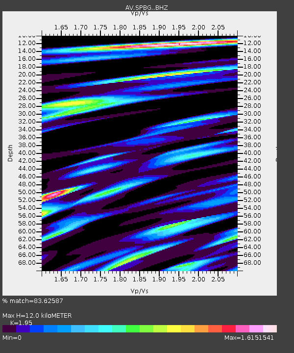
| Estimated Moho Depth: |
12.0 km |
| Estimated Crust Vp/Vs: |
1.95 |
| Assumed Crust Vp: |
6.566 km/s |
| Estimated Crust Vs: |
3.367 km/s |
| Estimated Crust Poisson's Ratio: |
0.32 |
|
| Radial Match: |
83.62587 % |
| Radial Bump: |
400 |
| Transverse Match: |
70.53704 % |
| Transverse Bump: |
400 |
| SOD ConfigId: |
13570011 |
| Insert Time: |
2019-04-30 14:21:11.057 +0000 |
| GWidth: |
2.5 |
| Max Bumps: |
400 |
| Tol: |
0.001 |
|

Signal To Noise
| Channel | StoN | STA | LTA |
| AV:SPBG: :BHZ:20180719T13:41:08.699023Z | 14.575279 | 1.2700852E-6 | 8.713968E-8 |
| AV:SPBG: :BHN:20180719T13:41:08.699023Z | 5.169634 | 5.2527844E-7 | 1.01608435E-7 |
| AV:SPBG: :BHE:20180719T13:41:08.699023Z | 17.11646 | 1.2286218E-6 | 7.178014E-8 |
| Arrivals |
| Ps | 1.8 SECOND |
| PpPs | 5.1 SECOND |
| PsPs/PpSs | 7.0 SECOND |


