You are here: Home > Network List > CI - Caltech Regional Seismic Network Stations List
> Station MPP McPhearson Peak > Earthquake Result Viewer
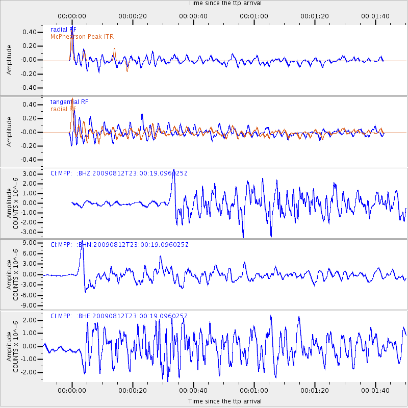
MPP McPhearson Peak - Earthquake Result Viewer
*The percent match for this event was below the threshold and hence no stack was calculated.
| Earthquake location: |
Southeast Of Honshu, Japan |
| Earthquake latitude/longitude: |
32.8/140.4 |
| Earthquake time(UTC): |
2009/08/12 (224) 22:48:51 GMT |
| Earthquake Depth: |
53 km |
| Earthquake Magnitude: |
6.2 MB, 6.6 MW, 6.6 MW |
| Earthquake Catalog/Contributor: |
WHDF/NEIC |
|
| Network: |
CI Caltech Regional Seismic Network |
| Station: |
MPP McPhearson Peak |
| Lat/Lon: |
34.89 N/119.81 W |
| Elevation: |
1739 m |
|
| Distance: |
79.1 deg |
| Az: |
55.591 deg |
| Baz: |
302.322 deg |
| Ray Param: |
$rayparam |
*The percent match for this event was below the threshold and hence was not used in the summary stack. |
|
| Radial Match: |
88.75157 % |
| Radial Bump: |
400 |
| Transverse Match: |
82.604 % |
| Transverse Bump: |
400 |
| SOD ConfigId: |
2622 |
| Insert Time: |
2010-02-26 02:05:20.095 +0000 |
| GWidth: |
2.5 |
| Max Bumps: |
400 |
| Tol: |
0.001 |
|
Signal To Noise
| Channel | StoN | STA | LTA |
| CI:MPP: :BHN:20090812T23:00:19.096025Z | 40.181446 | 4.025916E-6 | 1.0019341E-7 |
| CI:MPP: :BHE:20090812T23:00:19.096025Z | 2.7628634 | 9.219372E-7 | 3.3368903E-7 |
| CI:MPP: :BHZ:20090812T23:00:19.096025Z | 9.226993 | 1.4875291E-6 | 1.6121493E-7 |
| Arrivals |
| Ps | |
| PpPs | |
| PsPs/PpSs | |


