You are here: Home > Network List > CI - Caltech Regional Seismic Network Stations List
> Station MPP McPhearson Peak > Earthquake Result Viewer
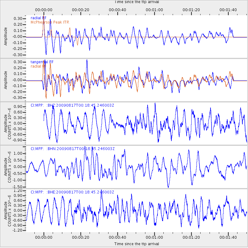
MPP McPhearson Peak - Earthquake Result Viewer
*The percent match for this event was below the threshold and hence no stack was calculated.
| Earthquake location: |
Southwestern Ryukyu Isl., Japan |
| Earthquake latitude/longitude: |
23.5/123.5 |
| Earthquake time(UTC): |
2009/08/17 (229) 00:05:49 GMT |
| Earthquake Depth: |
20 km |
| Earthquake Magnitude: |
6.2 MB, 6.6 MS, 6.7 MW, 6.6 MW |
| Earthquake Catalog/Contributor: |
WHDF/NEIC |
|
| Network: |
CI Caltech Regional Seismic Network |
| Station: |
MPP McPhearson Peak |
| Lat/Lon: |
34.89 N/119.81 W |
| Elevation: |
1739 m |
|
| Distance: |
96.5 deg |
| Az: |
47.667 deg |
| Baz: |
304.357 deg |
| Ray Param: |
$rayparam |
*The percent match for this event was below the threshold and hence was not used in the summary stack. |
|
| Radial Match: |
63.43238 % |
| Radial Bump: |
400 |
| Transverse Match: |
59.82256 % |
| Transverse Bump: |
400 |
| SOD ConfigId: |
2622 |
| Insert Time: |
2010-02-26 02:05:21.586 +0000 |
| GWidth: |
2.5 |
| Max Bumps: |
400 |
| Tol: |
0.001 |
|
Signal To Noise
| Channel | StoN | STA | LTA |
| CI:MPP: :BHN:20090817T00:18:45.246003Z | 2.0573914 | 4.718902E-7 | 2.2936337E-7 |
| CI:MPP: :BHE:20090817T00:18:45.246003Z | 1.2391372 | 4.6017317E-7 | 3.713658E-7 |
| CI:MPP: :BHZ:20090817T00:18:45.246003Z | 1.1297925 | 5.196918E-7 | 4.5998877E-7 |
| Arrivals |
| Ps | |
| PpPs | |
| PsPs/PpSs | |


