You are here: Home > Network List > TA - USArray Transportable Network (new EarthScope stations) Stations List
> Station 526A Mary Lane Ranch, Marfa, TX, USA > Earthquake Result Viewer
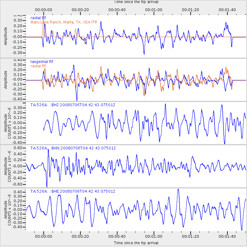
526A Mary Lane Ranch, Marfa, TX, USA - Earthquake Result Viewer
*The percent match for this event was below the threshold and hence no stack was calculated.
| Earthquake location: |
South Of Fiji Islands |
| Earthquake latitude/longitude: |
-25.5/-176.4 |
| Earthquake time(UTC): |
2008/07/06 (188) 04:30:26 GMT |
| Earthquake Depth: |
49 km |
| Earthquake Magnitude: |
5.5 MB, 5.3 MS |
| Earthquake Catalog/Contributor: |
WHDF/NEIC |
|
| Network: |
TA USArray Transportable Network (new EarthScope stations) |
| Station: |
526A Mary Lane Ranch, Marfa, TX, USA |
| Lat/Lon: |
30.06 N/104.09 W |
| Elevation: |
1405 m |
|
| Distance: |
88.5 deg |
| Az: |
55.69 deg |
| Baz: |
239.464 deg |
| Ray Param: |
$rayparam |
*The percent match for this event was below the threshold and hence was not used in the summary stack. |
|
| Radial Match: |
46.096767 % |
| Radial Bump: |
400 |
| Transverse Match: |
54.010612 % |
| Transverse Bump: |
305 |
| SOD ConfigId: |
2504 |
| Insert Time: |
2010-03-06 12:48:35.842 +0000 |
| GWidth: |
2.5 |
| Max Bumps: |
400 |
| Tol: |
0.001 |
|
Signal To Noise
| Channel | StoN | STA | LTA |
| TA:526A: :BHN:20080706T04:42:43.07501Z | 3.5331483 | 2.8239413E-7 | 7.9927055E-8 |
| TA:526A: :BHE:20080706T04:42:43.07501Z | 1.6436385 | 1.5196564E-7 | 9.245685E-8 |
| TA:526A: :BHZ:20080706T04:42:43.07501Z | 1.5688976 | 1.7154366E-7 | 1.0934025E-7 |
| Arrivals |
| Ps | |
| PpPs | |
| PsPs/PpSs | |


