You are here: Home > Network List > CI - Caltech Regional Seismic Network Stations List
> Station MPP McPhearson Peak > Earthquake Result Viewer
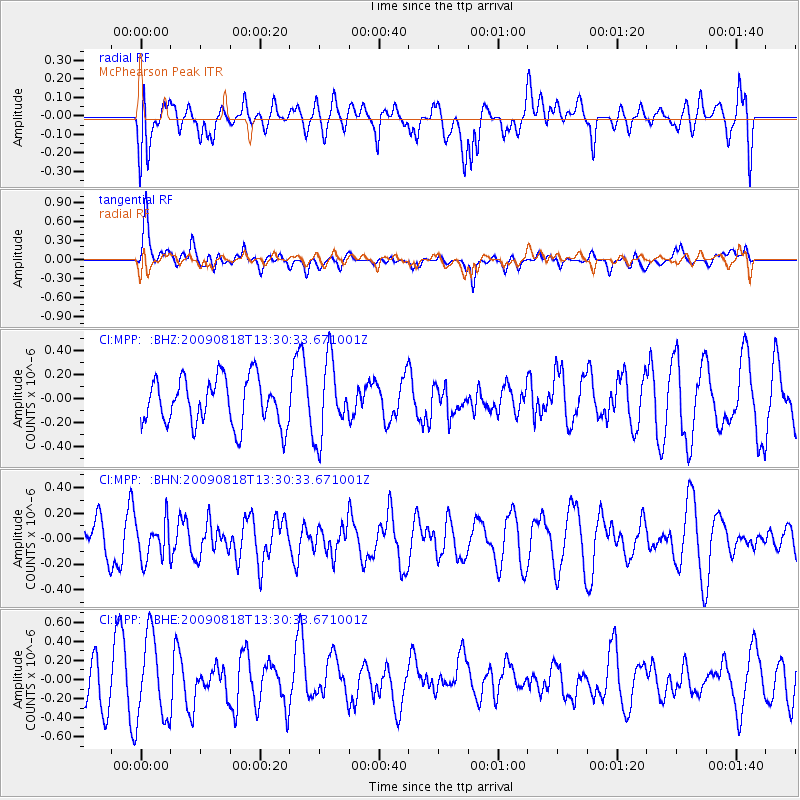
MPP McPhearson Peak - Earthquake Result Viewer
*The percent match for this event was below the threshold and hence no stack was calculated.
| Earthquake location: |
Southwestern Ryukyu Isl., Japan |
| Earthquake latitude/longitude: |
23.5/123.5 |
| Earthquake time(UTC): |
2009/08/18 (230) 13:17:35 GMT |
| Earthquake Depth: |
5.7 km |
| Earthquake Magnitude: |
5.6 MB, 5.2 MS |
| Earthquake Catalog/Contributor: |
WHDF/NEIC |
|
| Network: |
CI Caltech Regional Seismic Network |
| Station: |
MPP McPhearson Peak |
| Lat/Lon: |
34.89 N/119.81 W |
| Elevation: |
1739 m |
|
| Distance: |
96.5 deg |
| Az: |
47.673 deg |
| Baz: |
304.353 deg |
| Ray Param: |
$rayparam |
*The percent match for this event was below the threshold and hence was not used in the summary stack. |
|
| Radial Match: |
39.153214 % |
| Radial Bump: |
400 |
| Transverse Match: |
48.863518 % |
| Transverse Bump: |
400 |
| SOD ConfigId: |
2622 |
| Insert Time: |
2010-02-26 02:05:24.926 +0000 |
| GWidth: |
2.5 |
| Max Bumps: |
400 |
| Tol: |
0.001 |
|
Signal To Noise
| Channel | StoN | STA | LTA |
| CI:MPP: :BHN:20090818T13:30:33.671001Z | 1.0509105 | 1.4843202E-7 | 1.4124136E-7 |
| CI:MPP: :BHE:20090818T13:30:33.671001Z | 2.2741287 | 4.359003E-7 | 1.9167796E-7 |
| CI:MPP: :BHZ:20090818T13:30:33.671001Z | 1.6170118 | 3.1600462E-7 | 1.9542506E-7 |
| Arrivals |
| Ps | |
| PpPs | |
| PsPs/PpSs | |


