You are here: Home > Network List > TA - USArray Transportable Network (new EarthScope stations) Stations List
> Station 526A Mary Lane Ranch, Marfa, TX, USA > Earthquake Result Viewer
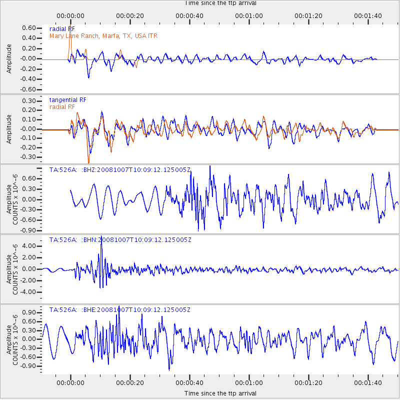
526A Mary Lane Ranch, Marfa, TX, USA - Earthquake Result Viewer
*The percent match for this event was below the threshold and hence no stack was calculated.
| Earthquake location: |
Arctic Ocean |
| Earthquake latitude/longitude: |
79.8/-115.4 |
| Earthquake time(UTC): |
2008/10/07 (281) 10:00:48 GMT |
| Earthquake Depth: |
10 km |
| Earthquake Magnitude: |
5.6 MB, 5.5 MS, 5.7 MW, 5.7 MW |
| Earthquake Catalog/Contributor: |
WHDF/NEIC |
|
| Network: |
TA USArray Transportable Network (new EarthScope stations) |
| Station: |
526A Mary Lane Ranch, Marfa, TX, USA |
| Lat/Lon: |
30.06 N/104.09 W |
| Elevation: |
1405 m |
|
| Distance: |
50.1 deg |
| Az: |
167.137 deg |
| Baz: |
357.381 deg |
| Ray Param: |
$rayparam |
*The percent match for this event was below the threshold and hence was not used in the summary stack. |
|
| Radial Match: |
47.396183 % |
| Radial Bump: |
400 |
| Transverse Match: |
54.66266 % |
| Transverse Bump: |
371 |
| SOD ConfigId: |
2556 |
| Insert Time: |
2010-03-06 12:48:45.440 +0000 |
| GWidth: |
2.5 |
| Max Bumps: |
400 |
| Tol: |
0.001 |
|
Signal To Noise
| Channel | StoN | STA | LTA |
| TA:526A: :BHN:20081007T10:09:12.125005Z | 3.03529 | 5.7875957E-7 | 1.9067686E-7 |
| TA:526A: :BHE:20081007T10:09:12.125005Z | 0.98951393 | 2.3728978E-7 | 2.398044E-7 |
| TA:526A: :BHZ:20081007T10:09:12.125005Z | 1.0551682 | 2.3998422E-7 | 2.2743696E-7 |
| Arrivals |
| Ps | |
| PpPs | |
| PsPs/PpSs | |


