You are here: Home > Network List > CI - Caltech Regional Seismic Network Stations List
> Station MPP McPhearson Peak > Earthquake Result Viewer
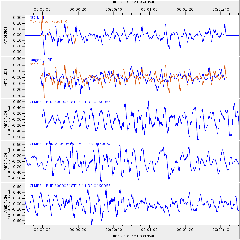
MPP McPhearson Peak - Earthquake Result Viewer
*The percent match for this event was below the threshold and hence no stack was calculated.
| Earthquake location: |
Solomon Islands |
| Earthquake latitude/longitude: |
-6.6/154.6 |
| Earthquake time(UTC): |
2009/08/18 (230) 17:59:13 GMT |
| Earthquake Depth: |
35 km |
| Earthquake Magnitude: |
5.6 MW, 5.4 MS, 5.3 MB, 5.6 MW |
| Earthquake Catalog/Contributor: |
WHDF/NEIC |
|
| Network: |
CI Caltech Regional Seismic Network |
| Station: |
MPP McPhearson Peak |
| Lat/Lon: |
34.89 N/119.81 W |
| Elevation: |
1739 m |
|
| Distance: |
90.2 deg |
| Az: |
55.051 deg |
| Baz: |
262.094 deg |
| Ray Param: |
$rayparam |
*The percent match for this event was below the threshold and hence was not used in the summary stack. |
|
| Radial Match: |
50.963337 % |
| Radial Bump: |
400 |
| Transverse Match: |
41.561554 % |
| Transverse Bump: |
400 |
| SOD ConfigId: |
2622 |
| Insert Time: |
2010-02-26 02:05:25.780 +0000 |
| GWidth: |
2.5 |
| Max Bumps: |
400 |
| Tol: |
0.001 |
|
Signal To Noise
| Channel | StoN | STA | LTA |
| CI:MPP: :BHN:20090818T18:11:39.046006Z | 2.6525135 | 2.9793765E-7 | 1.1232276E-7 |
| CI:MPP: :BHE:20090818T18:11:39.046006Z | 1.2362646 | 2.2853337E-7 | 1.8485797E-7 |
| CI:MPP: :BHZ:20090818T18:11:39.046006Z | 1.4229567 | 2.3768754E-7 | 1.6703778E-7 |
| Arrivals |
| Ps | |
| PpPs | |
| PsPs/PpSs | |


