You are here: Home > Network List > TA - USArray Transportable Network (new EarthScope stations) Stations List
> Station H18K Honhosa River, AK, USA > Earthquake Result Viewer
H18K Honhosa River, AK, USA - Earthquake Result Viewer
| Earthquake location: |
Oaxaca, Mexico |
| Earthquake latitude/longitude: |
17.8/-97.8 |
| Earthquake time(UTC): |
2018/07/19 (200) 13:31:53 GMT |
| Earthquake Depth: |
55 km |
| Earthquake Magnitude: |
5.7 Mww |
| Earthquake Catalog/Contributor: |
NEIC PDE/us |
|
| Network: |
TA USArray Transportable Network (new EarthScope stations) |
| Station: |
H18K Honhosa River, AK, USA |
| Lat/Lon: |
65.15 N/158.36 W |
| Elevation: |
494 m |
|
| Distance: |
61.8 deg |
| Az: |
335.304 deg |
| Baz: |
109.609 deg |
| Ray Param: |
0.060548373 |
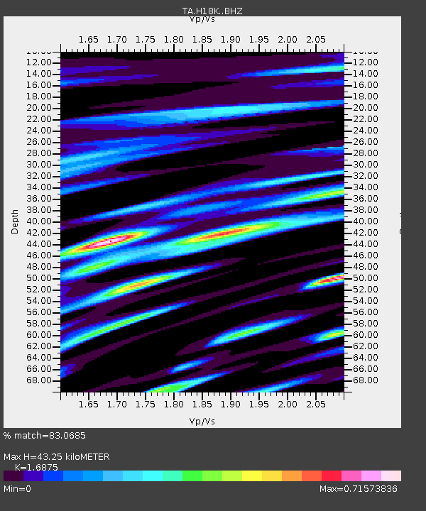
| Estimated Moho Depth: |
43.25 km |
| Estimated Crust Vp/Vs: |
1.69 |
| Assumed Crust Vp: |
6.1 km/s |
| Estimated Crust Vs: |
3.615 km/s |
| Estimated Crust Poisson's Ratio: |
0.23 |
|
| Radial Match: |
83.0685 % |
| Radial Bump: |
400 |
| Transverse Match: |
66.50011 % |
| Transverse Bump: |
400 |
| SOD ConfigId: |
13570011 |
| Insert Time: |
2019-04-30 14:26:49.872 +0000 |
| GWidth: |
2.5 |
| Max Bumps: |
400 |
| Tol: |
0.001 |
|

Signal To Noise
| Channel | StoN | STA | LTA |
| TA:H18K: :BHZ:20180719T13:41:35.850024Z | 9.033183 | 6.794432E-7 | 7.521636E-8 |
| TA:H18K: :BHN:20180719T13:41:35.850024Z | 1.4011092 | 8.584729E-8 | 6.1270946E-8 |
| TA:H18K: :BHE:20180719T13:41:35.850024Z | 6.056571 | 2.954942E-7 | 4.8789026E-8 |
| Arrivals |
| Ps | 5.1 SECOND |
| PpPs | 18 SECOND |
| PsPs/PpSs | 23 SECOND |


