You are here: Home > Network List > TA - USArray Transportable Network (new EarthScope stations) Stations List
> Station I21K Tanana, AK, USA > Earthquake Result Viewer
I21K Tanana, AK, USA - Earthquake Result Viewer
| Earthquake location: |
Oaxaca, Mexico |
| Earthquake latitude/longitude: |
17.8/-97.8 |
| Earthquake time(UTC): |
2018/07/19 (200) 13:31:53 GMT |
| Earthquake Depth: |
55 km |
| Earthquake Magnitude: |
5.7 Mww |
| Earthquake Catalog/Contributor: |
NEIC PDE/us |
|
| Network: |
TA USArray Transportable Network (new EarthScope stations) |
| Station: |
I21K Tanana, AK, USA |
| Lat/Lon: |
65.18 N/151.98 W |
| Elevation: |
248 m |
|
| Distance: |
59.3 deg |
| Az: |
336.533 deg |
| Baz: |
115.999 deg |
| Ray Param: |
0.06215766 |
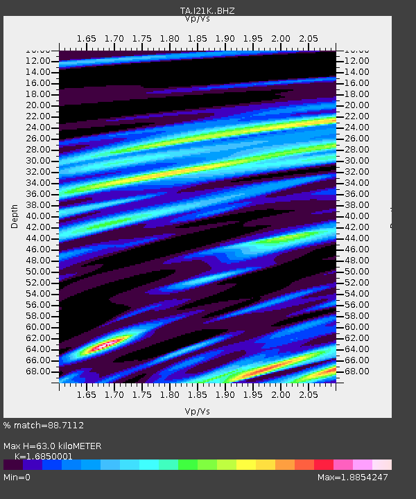
| Estimated Moho Depth: |
63.0 km |
| Estimated Crust Vp/Vs: |
1.69 |
| Assumed Crust Vp: |
6.566 km/s |
| Estimated Crust Vs: |
3.897 km/s |
| Estimated Crust Poisson's Ratio: |
0.23 |
|
| Radial Match: |
88.7112 % |
| Radial Bump: |
400 |
| Transverse Match: |
84.56987 % |
| Transverse Bump: |
400 |
| SOD ConfigId: |
13570011 |
| Insert Time: |
2019-04-30 14:27:00.609 +0000 |
| GWidth: |
2.5 |
| Max Bumps: |
400 |
| Tol: |
0.001 |
|

Signal To Noise
| Channel | StoN | STA | LTA |
| TA:I21K: :BHZ:20180719T13:41:18.999988Z | 25.108736 | 1.5319373E-6 | 6.101212E-8 |
| TA:I21K: :BHN:20180719T13:41:18.999988Z | 5.114629 | 3.8595115E-7 | 7.546025E-8 |
| TA:I21K: :BHE:20180719T13:41:18.999988Z | 7.8919487 | 5.414747E-7 | 6.861102E-8 |
| Arrivals |
| Ps | 6.9 SECOND |
| PpPs | 24 SECOND |
| PsPs/PpSs | 31 SECOND |


