You are here: Home > Network List > TA - USArray Transportable Network (new EarthScope stations) Stations List
> Station N17K Nushagak Hills, AK, USA > Earthquake Result Viewer
N17K Nushagak Hills, AK, USA - Earthquake Result Viewer
| Earthquake location: |
Oaxaca, Mexico |
| Earthquake latitude/longitude: |
17.8/-97.8 |
| Earthquake time(UTC): |
2018/07/19 (200) 13:31:53 GMT |
| Earthquake Depth: |
55 km |
| Earthquake Magnitude: |
5.7 Mww |
| Earthquake Catalog/Contributor: |
NEIC PDE/us |
|
| Network: |
TA USArray Transportable Network (new EarthScope stations) |
| Station: |
N17K Nushagak Hills, AK, USA |
| Lat/Lon: |
60.53 N/157.19 W |
| Elevation: |
350 m |
|
| Distance: |
59.7 deg |
| Az: |
330.471 deg |
| Baz: |
108.292 deg |
| Ray Param: |
0.061862107 |
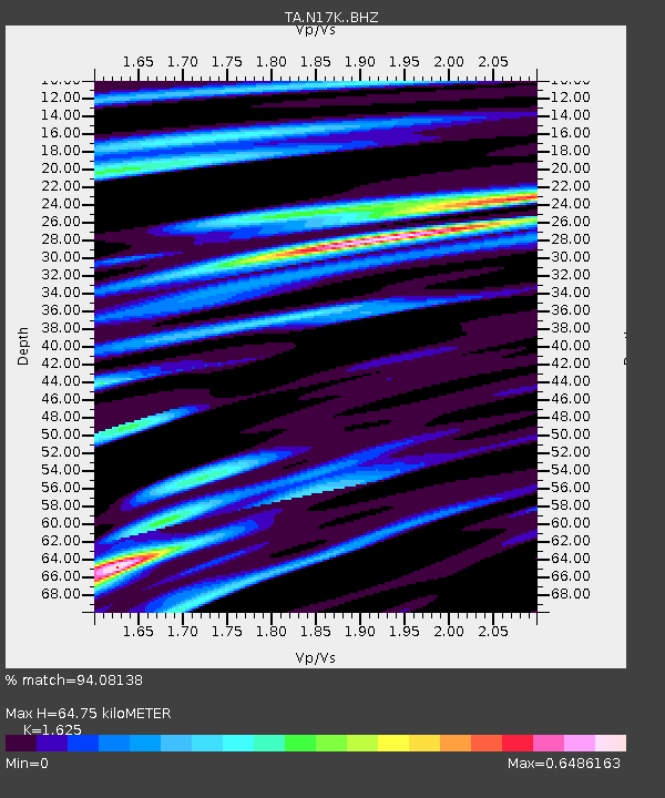
| Estimated Moho Depth: |
64.75 km |
| Estimated Crust Vp/Vs: |
1.62 |
| Assumed Crust Vp: |
6.155 km/s |
| Estimated Crust Vs: |
3.788 km/s |
| Estimated Crust Poisson's Ratio: |
0.20 |
|
| Radial Match: |
94.08138 % |
| Radial Bump: |
400 |
| Transverse Match: |
86.477745 % |
| Transverse Bump: |
400 |
| SOD ConfigId: |
13570011 |
| Insert Time: |
2019-04-30 14:27:42.277 +0000 |
| GWidth: |
2.5 |
| Max Bumps: |
400 |
| Tol: |
0.001 |
|

Signal To Noise
| Channel | StoN | STA | LTA |
| TA:N17K: :BHZ:20180719T13:41:22.174976Z | 20.2195 | 1.3482329E-6 | 6.667984E-8 |
| TA:N17K: :BHN:20180719T13:41:22.174976Z | 2.730467 | 1.6565386E-7 | 6.066869E-8 |
| TA:N17K: :BHE:20180719T13:41:22.174976Z | 10.742958 | 5.8121066E-7 | 5.4101548E-8 |
| Arrivals |
| Ps | 6.9 SECOND |
| PpPs | 26 SECOND |
| PsPs/PpSs | 33 SECOND |


