You are here: Home > Network List > TA - USArray Transportable Network (new EarthScope stations) Stations List
> Station A17A Triple J Farms, Joplin, MT, USA > Earthquake Result Viewer
A17A Triple J Farms, Joplin, MT, USA - Earthquake Result Viewer
| Earthquake location: |
Off Coast Of Jalisco, Mexico |
| Earthquake latitude/longitude: |
17.6/-105.5 |
| Earthquake time(UTC): |
2008/09/24 (268) 02:33:05 GMT |
| Earthquake Depth: |
10 km |
| Earthquake Magnitude: |
5.7 MB, 6.2 MS, 6.4 MW, 6.4 MW |
| Earthquake Catalog/Contributor: |
WHDF/NEIC |
|
| Network: |
TA USArray Transportable Network (new EarthScope stations) |
| Station: |
A17A Triple J Farms, Joplin, MT, USA |
| Lat/Lon: |
48.94 N/110.70 W |
| Elevation: |
973 m |
|
| Distance: |
31.5 deg |
| Az: |
353.442 deg |
| Baz: |
170.49 deg |
| Ray Param: |
0.079032645 |
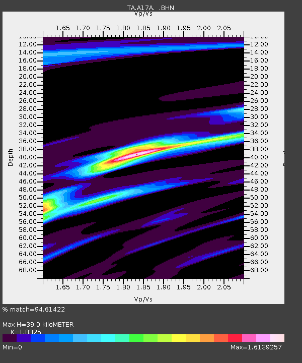
| Estimated Moho Depth: |
39.0 km |
| Estimated Crust Vp/Vs: |
1.83 |
| Assumed Crust Vp: |
6.242 km/s |
| Estimated Crust Vs: |
3.406 km/s |
| Estimated Crust Poisson's Ratio: |
0.29 |
|
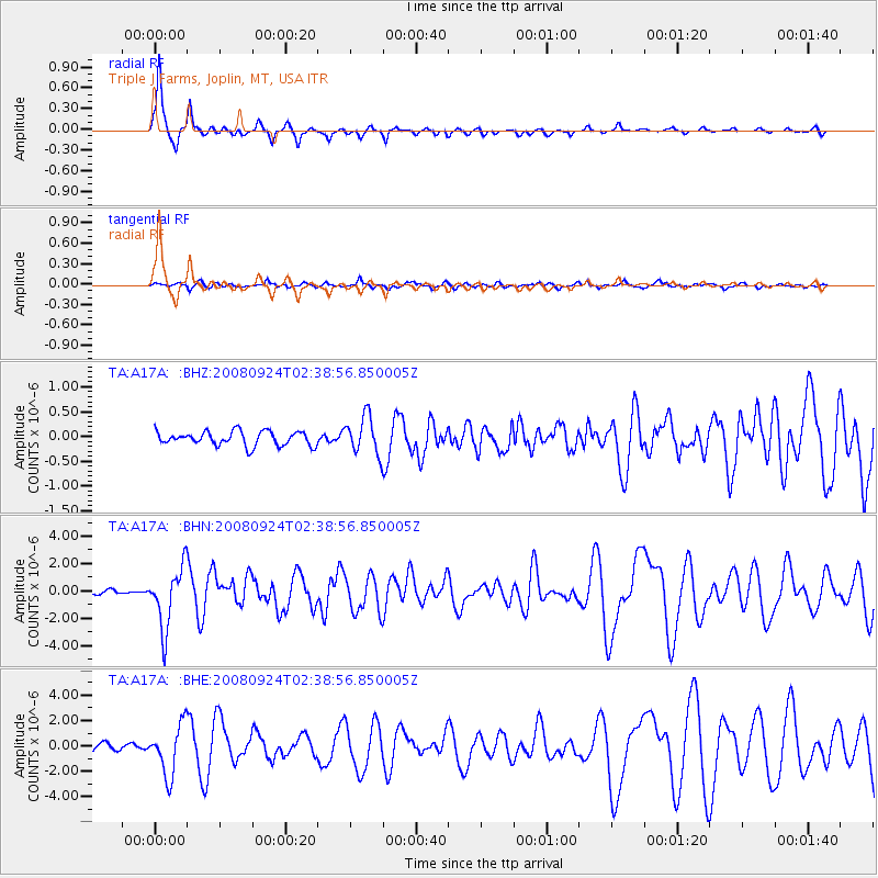
| Radial Match: |
94.61422 % |
| Radial Bump: |
260 |
| Transverse Match: |
71.98469 % |
| Transverse Bump: |
400 |
| SOD ConfigId: |
2560 |
| Insert Time: |
2010-03-06 12:49:34.514 +0000 |
| GWidth: |
2.5 |
| Max Bumps: |
400 |
| Tol: |
0.001 |
|
Signal To Noise
| Channel | StoN | STA | LTA |
| TA:A17A: :BHN:20080924T02:38:56.850005Z | 19.305393 | 2.2069341E-6 | 1.1431698E-7 |
| TA:A17A: :BHE:20080924T02:38:56.850005Z | 11.354211 | 1.975663E-6 | 1.7400268E-7 |
| TA:A17A: :BHZ:20080924T02:38:56.850005Z | 2.6706512 | 3.8189762E-7 | 1.4299793E-7 |
| Arrivals |
| Ps | 5.6 SECOND |
| PpPs | 16 SECOND |
| PsPs/PpSs | 22 SECOND |


