You are here: Home > Network List > TA - USArray Transportable Network (new EarthScope stations) Stations List
> Station A17A Triple J Farms, Joplin, MT, USA > Earthquake Result Viewer
A17A Triple J Farms, Joplin, MT, USA - Earthquake Result Viewer
| Earthquake location: |
Bonin Islands, Japan Region |
| Earthquake latitude/longitude: |
26.8/142.4 |
| Earthquake time(UTC): |
2008/02/27 (058) 06:54:20 GMT |
| Earthquake Depth: |
15 km |
| Earthquake Magnitude: |
5.8 MB, 6.1 MS, 6.2 MW, 6.2 MW |
| Earthquake Catalog/Contributor: |
WHDF/NEIC |
|
| Network: |
TA USArray Transportable Network (new EarthScope stations) |
| Station: |
A17A Triple J Farms, Joplin, MT, USA |
| Lat/Lon: |
48.94 N/110.70 W |
| Elevation: |
973 m |
|
| Distance: |
80.4 deg |
| Az: |
39.782 deg |
| Baz: |
299.848 deg |
| Ray Param: |
0.0482816 |
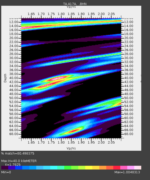
| Estimated Moho Depth: |
40.0 km |
| Estimated Crust Vp/Vs: |
1.78 |
| Assumed Crust Vp: |
6.242 km/s |
| Estimated Crust Vs: |
3.502 km/s |
| Estimated Crust Poisson's Ratio: |
0.27 |
|
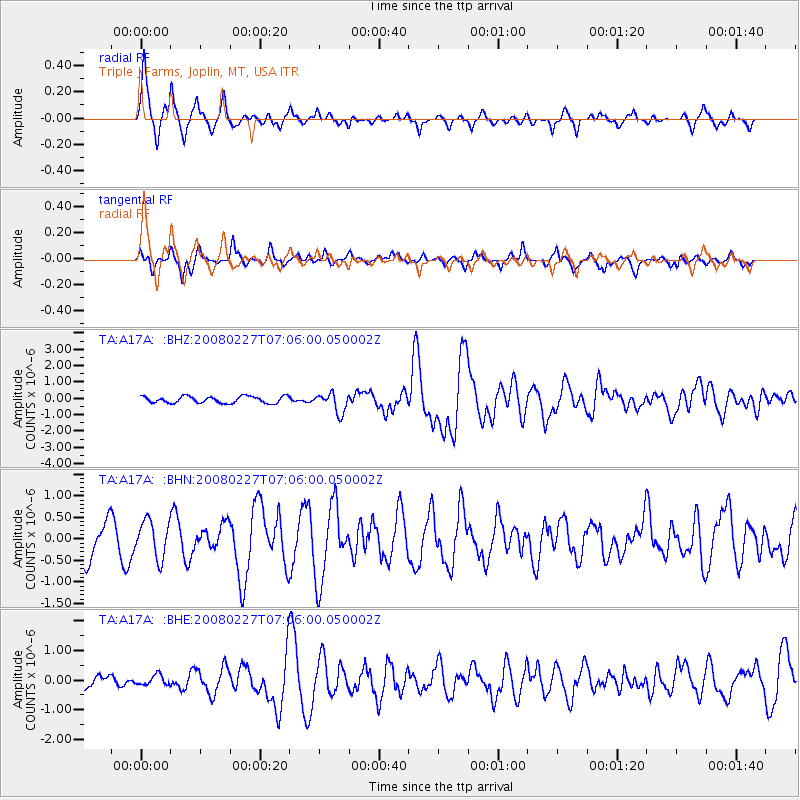
| Radial Match: |
80.498375 % |
| Radial Bump: |
338 |
| Transverse Match: |
57.49772 % |
| Transverse Bump: |
356 |
| SOD ConfigId: |
2564 |
| Insert Time: |
2010-03-06 12:49:36.620 +0000 |
| GWidth: |
2.5 |
| Max Bumps: |
400 |
| Tol: |
0.001 |
|
Signal To Noise
| Channel | StoN | STA | LTA |
| TA:A17A: :BHN:20080227T07:06:00.050002Z | 0.9515479 | 4.2704878E-7 | 4.487938E-7 |
| TA:A17A: :BHE:20080227T07:06:00.050002Z | 0.60227895 | 1.6791687E-7 | 2.788025E-7 |
| TA:A17A: :BHZ:20080227T07:06:00.050002Z | 2.9284356 | 5.9884553E-7 | 2.0449333E-7 |
| Arrivals |
| Ps | 5.1 SECOND |
| PpPs | 17 SECOND |
| PsPs/PpSs | 23 SECOND |


