You are here: Home > Network List > TA - USArray Transportable Network (new EarthScope stations) Stations List
> Station A17A Triple J Farms, Joplin, MT, USA > Earthquake Result Viewer
A17A Triple J Farms, Joplin, MT, USA - Earthquake Result Viewer
| Earthquake location: |
North Of Honduras |
| Earthquake latitude/longitude: |
16.7/-86.2 |
| Earthquake time(UTC): |
2009/05/28 (148) 08:24:45 GMT |
| Earthquake Depth: |
10 km |
| Earthquake Magnitude: |
6.7 MB, 7.2 MS, 7.3 MW, 7.3 MW |
| Earthquake Catalog/Contributor: |
WHDF/NEIC |
|
| Network: |
TA USArray Transportable Network (new EarthScope stations) |
| Station: |
A17A Triple J Farms, Joplin, MT, USA |
| Lat/Lon: |
48.94 N/110.70 W |
| Elevation: |
973 m |
|
| Distance: |
37.8 deg |
| Az: |
333.552 deg |
| Baz: |
139.659 deg |
| Ray Param: |
0.07592409 |
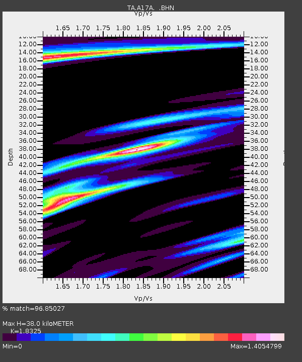
| Estimated Moho Depth: |
38.0 km |
| Estimated Crust Vp/Vs: |
1.83 |
| Assumed Crust Vp: |
6.242 km/s |
| Estimated Crust Vs: |
3.406 km/s |
| Estimated Crust Poisson's Ratio: |
0.29 |
|
| Radial Match: |
96.85027 % |
| Radial Bump: |
289 |
| Transverse Match: |
84.0907 % |
| Transverse Bump: |
379 |
| SOD ConfigId: |
2648 |
| Insert Time: |
2010-03-06 12:50:01.300 +0000 |
| GWidth: |
2.5 |
| Max Bumps: |
400 |
| Tol: |
0.001 |
|

Signal To Noise
| Channel | StoN | STA | LTA |
| TA:A17A: :BHN:20090528T08:31:30.750013Z | 9.790588 | 1.0643809E-6 | 1.08714694E-7 |
| TA:A17A: :BHE:20090528T08:31:30.750013Z | 3.1459537 | 4.4361144E-7 | 1.4101016E-7 |
| TA:A17A: :BHZ:20090528T08:31:30.750013Z | 3.517115 | 4.4806367E-7 | 1.2739523E-7 |
| Arrivals |
| Ps | 5.4 SECOND |
| PpPs | 16 SECOND |
| PsPs/PpSs | 22 SECOND |


