You are here: Home > Network List > UW - Pacific Northwest Regional Seismic Network Stations List
> Station HOOD Mt Hood Meadows, OR CREST BB SMO > Earthquake Result Viewer
HOOD Mt Hood Meadows, OR CREST BB SMO - Earthquake Result Viewer

| Earthquake location: |
Oaxaca, Mexico |
| Earthquake latitude/longitude: |
17.8/-97.8 |
| Earthquake time(UTC): |
2018/07/19 (200) 13:31:53 GMT |
| Earthquake Depth: |
55 km |
| Earthquake Magnitude: |
5.7 Mww |
| Earthquake Catalog/Contributor: |
NEIC PDE/us |
|
| Network: |
UW Pacific Northwest Regional Seismic Network |
| Station: |
HOOD Mt Hood Meadows, OR CREST BB SMO |
| Lat/Lon: |
45.32 N/121.65 W |
| Elevation: |
1520 m |
|
| Distance: |
33.9 deg |
| Az: |
329.202 deg |
| Baz: |
136.261 deg |
| Ray Param: |
0.07787058 |
| Estimated Moho Depth: |
28.5 km |
| Estimated Crust Vp/Vs: |
2.10 |
| Assumed Crust Vp: |
6.597 km/s |
| Estimated Crust Vs: |
3.145 km/s |
| Estimated Crust Poisson's Ratio: |
0.35 |
|
| Radial Match: |
86.76202 % |
| Radial Bump: |
400 |
| Transverse Match: |
82.35487 % |
| Transverse Bump: |
400 |
| SOD ConfigId: |
13570011 |
| Insert Time: |
2019-04-30 14:28:53.566 +0000 |
| GWidth: |
2.5 |
| Max Bumps: |
400 |
| Tol: |
0.001 |
|
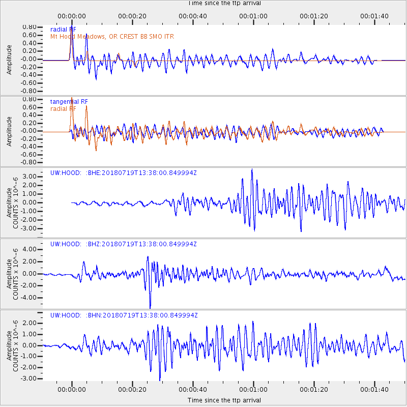
Signal To Noise
| Channel | StoN | STA | LTA |
| UW:HOOD: :BHZ:20180719T13:38:00.849994Z | 12.81539 | 8.210765E-7 | 6.4069575E-8 |
| UW:HOOD: :BHN:20180719T13:38:00.849994Z | 4.69513 | 3.8594902E-7 | 8.220199E-8 |
| UW:HOOD: :BHE:20180719T13:38:00.849994Z | 3.212663 | 4.690779E-7 | 1.4600906E-7 |
| Arrivals |
| Ps | 5.1 SECOND |
| PpPs | 12 SECOND |
| PsPs/PpSs | 18 SECOND |


