You are here: Home > Network List > XO18 - AACE: Alaska Amphibious Community seismic Experimen Stations List
> Station EP16 Levelock, AK > Earthquake Result Viewer
EP16 Levelock, AK - Earthquake Result Viewer
| Earthquake location: |
Oaxaca, Mexico |
| Earthquake latitude/longitude: |
17.8/-97.8 |
| Earthquake time(UTC): |
2018/07/19 (200) 13:31:53 GMT |
| Earthquake Depth: |
55 km |
| Earthquake Magnitude: |
5.7 Mww |
| Earthquake Catalog/Contributor: |
NEIC PDE/us |
|
| Network: |
XO AACE: Alaska Amphibious Community seismic Experimen |
| Station: |
EP16 Levelock, AK |
| Lat/Lon: |
59.11 N/156.86 W |
| Elevation: |
46 m |
|
| Distance: |
59.1 deg |
| Az: |
328.964 deg |
| Baz: |
107.811 deg |
| Ray Param: |
0.062253907 |
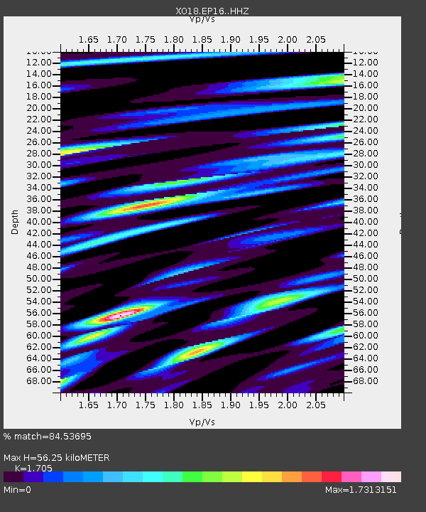
| Estimated Moho Depth: |
56.25 km |
| Estimated Crust Vp/Vs: |
1.71 |
| Assumed Crust Vp: |
6.276 km/s |
| Estimated Crust Vs: |
3.681 km/s |
| Estimated Crust Poisson's Ratio: |
0.24 |
|
| Radial Match: |
84.53695 % |
| Radial Bump: |
400 |
| Transverse Match: |
79.690704 % |
| Transverse Bump: |
400 |
| SOD ConfigId: |
13570011 |
| Insert Time: |
2019-04-30 14:29:32.553 +0000 |
| GWidth: |
2.5 |
| Max Bumps: |
400 |
| Tol: |
0.001 |
|

Signal To Noise
| Channel | StoN | STA | LTA |
| XO:EP16: :HHZ:20180719T13:41:18.069995Z | 20.904173 | 1.6688824E-6 | 7.98349E-8 |
| XO:EP16: :HHN:20180719T13:41:18.069995Z | 2.2582536 | 3.3393584E-7 | 1.478735E-7 |
| XO:EP16: :HHE:20180719T13:41:18.069995Z | 6.37048 | 7.440646E-7 | 1.1679883E-7 |
| Arrivals |
| Ps | 6.6 SECOND |
| PpPs | 23 SECOND |
| PsPs/PpSs | 30 SECOND |


