You are here: Home > Network List > TA - USArray Transportable Network (new EarthScope stations) Stations List
> Station A17A Triple J Farms, Joplin, MT, USA > Earthquake Result Viewer
A17A Triple J Farms, Joplin, MT, USA - Earthquake Result Viewer
| Earthquake location: |
Tonga Islands Region |
| Earthquake latitude/longitude: |
-23.0/-174.7 |
| Earthquake time(UTC): |
2009/03/19 (078) 18:17:40 GMT |
| Earthquake Depth: |
34 km |
| Earthquake Magnitude: |
7.0 MB, 7.6 MS, 7.6 MW, 7.6 MW |
| Earthquake Catalog/Contributor: |
WHDF/NEIC |
|
| Network: |
TA USArray Transportable Network (new EarthScope stations) |
| Station: |
A17A Triple J Farms, Joplin, MT, USA |
| Lat/Lon: |
48.94 N/110.70 W |
| Elevation: |
973 m |
|
| Distance: |
91.5 deg |
| Az: |
36.339 deg |
| Baz: |
235.884 deg |
| Ray Param: |
0.04159252 |
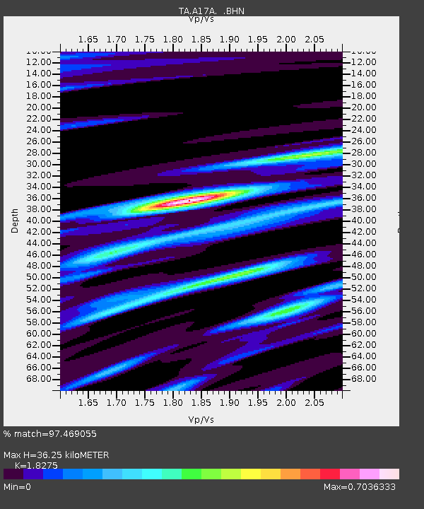
| Estimated Moho Depth: |
36.25 km |
| Estimated Crust Vp/Vs: |
1.83 |
| Assumed Crust Vp: |
6.242 km/s |
| Estimated Crust Vs: |
3.416 km/s |
| Estimated Crust Poisson's Ratio: |
0.29 |
|
| Radial Match: |
97.469055 % |
| Radial Bump: |
400 |
| Transverse Match: |
87.611244 % |
| Transverse Bump: |
400 |
| SOD ConfigId: |
2658 |
| Insert Time: |
2010-03-06 12:50:25.649 +0000 |
| GWidth: |
2.5 |
| Max Bumps: |
400 |
| Tol: |
0.001 |
|
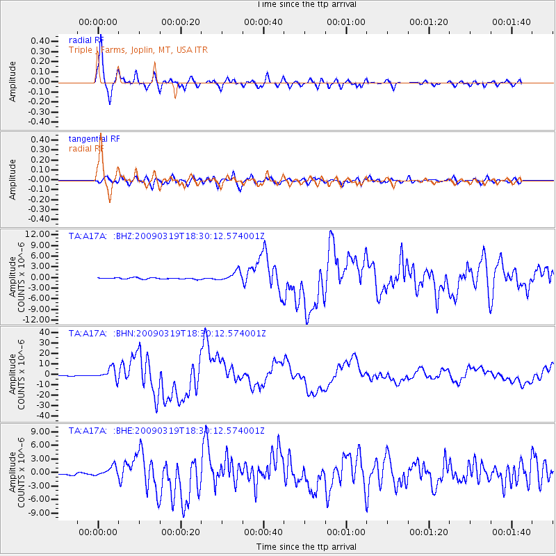
Signal To Noise
| Channel | StoN | STA | LTA |
| TA:A17A: :BHN:20090319T18:30:12.574001Z | 26.345425 | 5.7159095E-6 | 2.1696025E-7 |
| TA:A17A: :BHE:20090319T18:30:12.574001Z | 4.6935873 | 1.1325408E-6 | 2.4129534E-7 |
| TA:A17A: :BHZ:20090319T18:30:12.574001Z | 7.573452 | 1.4474314E-6 | 1.911191E-7 |
| Arrivals |
| Ps | 4.9 SECOND |
| PpPs | 16 SECOND |
| PsPs/PpSs | 21 SECOND |


