You are here: Home > Network List > AZ - ANZA Regional Network Stations List
> Station TMSP TMSP, CA, USA > Earthquake Result Viewer
TMSP TMSP, CA, USA - Earthquake Result Viewer
| Earthquake location: |
Alaska Peninsula |
| Earthquake latitude/longitude: |
54.4/-160.8 |
| Earthquake time(UTC): |
2018/07/19 (200) 14:16:27 GMT |
| Earthquake Depth: |
22 km |
| Earthquake Magnitude: |
5.8 Mww |
| Earthquake Catalog/Contributor: |
NEIC PDE/us |
|
| Network: |
AZ ANZA Regional Network |
| Station: |
TMSP TMSP, CA, USA |
| Lat/Lon: |
33.62 N/116.68 W |
| Elevation: |
2077 m |
|
| Distance: |
37.1 deg |
| Az: |
105.81 deg |
| Baz: |
317.668 deg |
| Ray Param: |
0.076272495 |
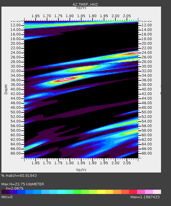
| Estimated Moho Depth: |
23.75 km |
| Estimated Crust Vp/Vs: |
2.10 |
| Assumed Crust Vp: |
6.264 km/s |
| Estimated Crust Vs: |
2.986 km/s |
| Estimated Crust Poisson's Ratio: |
0.35 |
|
| Radial Match: |
80.81843 % |
| Radial Bump: |
388 |
| Transverse Match: |
65.03322 % |
| Transverse Bump: |
400 |
| SOD ConfigId: |
13570011 |
| Insert Time: |
2019-04-30 14:31:12.145 +0000 |
| GWidth: |
2.5 |
| Max Bumps: |
400 |
| Tol: |
0.001 |
|

Signal To Noise
| Channel | StoN | STA | LTA |
| AZ:TMSP: :HHZ:20180719T14:23:05.478995Z | 3.623216 | 3.6254553E-7 | 1.00061804E-7 |
| AZ:TMSP: :HHN:20180719T14:23:05.478995Z | 1.3559899 | 2.3373602E-7 | 1.7237298E-7 |
| AZ:TMSP: :HHE:20180719T14:23:05.478995Z | 1.2739142 | 1.8394486E-7 | 1.4439345E-7 |
| Arrivals |
| Ps | 4.4 SECOND |
| PpPs | 11 SECOND |
| PsPs/PpSs | 15 SECOND |


