You are here: Home > Network List > TA - USArray Transportable Network (new EarthScope stations) Stations List
> Station A17A Triple J Farms, Joplin, MT, USA > Earthquake Result Viewer
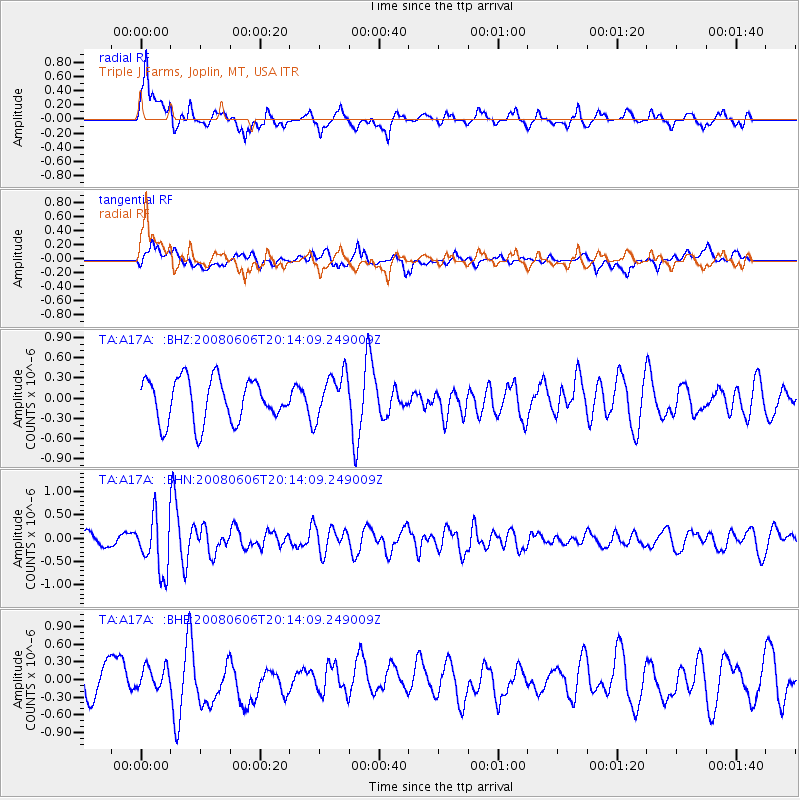
A17A Triple J Farms, Joplin, MT, USA - Earthquake Result Viewer
*The percent match for this event was below the threshold and hence no stack was calculated.
| Earthquake location: |
Northern Algeria |
| Earthquake latitude/longitude: |
35.9/-0.7 |
| Earthquake time(UTC): |
2008/06/06 (158) 20:02:56 GMT |
| Earthquake Depth: |
4.0 km |
| Earthquake Magnitude: |
5.5 MB, 5.3 MS, 5.5 MW, 5.5 MW |
| Earthquake Catalog/Contributor: |
WHDF/NEIC |
|
| Network: |
TA USArray Transportable Network (new EarthScope stations) |
| Station: |
A17A Triple J Farms, Joplin, MT, USA |
| Lat/Lon: |
48.94 N/110.70 W |
| Elevation: |
973 m |
|
| Distance: |
75.2 deg |
| Az: |
320.164 deg |
| Baz: |
52.097 deg |
| Ray Param: |
$rayparam |
*The percent match for this event was below the threshold and hence was not used in the summary stack. |
|
| Radial Match: |
77.081184 % |
| Radial Bump: |
400 |
| Transverse Match: |
56.079556 % |
| Transverse Bump: |
400 |
| SOD ConfigId: |
2504 |
| Insert Time: |
2010-03-06 12:51:27.612 +0000 |
| GWidth: |
2.5 |
| Max Bumps: |
400 |
| Tol: |
0.001 |
|
Signal To Noise
| Channel | StoN | STA | LTA |
| TA:A17A: :BHN:20080606T20:14:09.249009Z | 2.626949 | 5.9625404E-7 | 2.2697587E-7 |
| TA:A17A: :BHE:20080606T20:14:09.249009Z | 0.7078208 | 1.8212664E-7 | 2.5730617E-7 |
| TA:A17A: :BHZ:20080606T20:14:09.249009Z | 1.046872 | 3.3272292E-7 | 3.1782577E-7 |
| Arrivals |
| Ps | |
| PpPs | |
| PsPs/PpSs | |


