You are here: Home > Network List > TA - USArray Transportable Network (new EarthScope stations) Stations List
> Station A17A Triple J Farms, Joplin, MT, USA > Earthquake Result Viewer
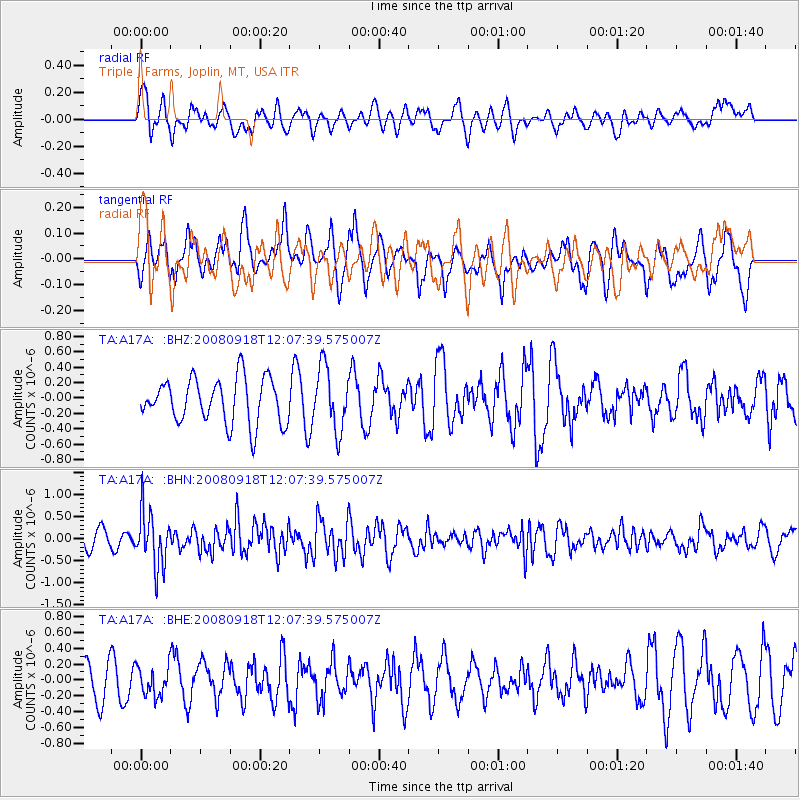
A17A Triple J Farms, Joplin, MT, USA - Earthquake Result Viewer
*The percent match for this event was below the threshold and hence no stack was calculated.
| Earthquake location: |
Near East Coast Of Kamchatka |
| Earthquake latitude/longitude: |
51.9/158.4 |
| Earthquake time(UTC): |
2008/09/18 (262) 11:58:50 GMT |
| Earthquake Depth: |
67 km |
| Earthquake Magnitude: |
5.7 MB, 5.9 MW, 5.8 MW |
| Earthquake Catalog/Contributor: |
WHDF/NEIC |
|
| Network: |
TA USArray Transportable Network (new EarthScope stations) |
| Station: |
A17A Triple J Farms, Joplin, MT, USA |
| Lat/Lon: |
48.94 N/110.70 W |
| Elevation: |
973 m |
|
| Distance: |
54.3 deg |
| Az: |
54.286 deg |
| Baz: |
310.295 deg |
| Ray Param: |
$rayparam |
*The percent match for this event was below the threshold and hence was not used in the summary stack. |
|
| Radial Match: |
44.62972 % |
| Radial Bump: |
400 |
| Transverse Match: |
52.793903 % |
| Transverse Bump: |
350 |
| SOD ConfigId: |
2560 |
| Insert Time: |
2010-03-06 12:51:42.167 +0000 |
| GWidth: |
2.5 |
| Max Bumps: |
400 |
| Tol: |
0.001 |
|
Signal To Noise
| Channel | StoN | STA | LTA |
| TA:A17A: :BHN:20080918T12:07:39.575007Z | 2.512477 | 6.149038E-7 | 2.4474008E-7 |
| TA:A17A: :BHE:20080918T12:07:39.575007Z | 0.83518904 | 1.8216568E-7 | 2.1811312E-7 |
| TA:A17A: :BHZ:20080918T12:07:39.575007Z | 1.3928194 | 4.0475584E-7 | 2.9060183E-7 |
| Arrivals |
| Ps | |
| PpPs | |
| PsPs/PpSs | |


