You are here: Home > Network List > IU - Global Seismograph Network (GSN - IRIS/USGS) Stations List
> Station PMG Port Moresby, New Guinea > Earthquake Result Viewer
PMG Port Moresby, New Guinea - Earthquake Result Viewer
*The percent match for this event was below the threshold and hence no stack was calculated.
| Earthquake location: |
South Of Fiji Islands |
| Earthquake latitude/longitude: |
-23.7/-179.9 |
| Earthquake time(UTC): |
2016/06/07 (159) 07:02:52 GMT |
| Earthquake Depth: |
523 km |
| Earthquake Magnitude: |
5.5 MB |
| Earthquake Catalog/Contributor: |
NEIC PDE/NEIC COMCAT |
|
| Network: |
IU Global Seismograph Network (GSN - IRIS/USGS) |
| Station: |
PMG Port Moresby, New Guinea |
| Lat/Lon: |
9.40 S/147.16 E |
| Elevation: |
90 m |
|
| Distance: |
34.5 deg |
| Az: |
288.649 deg |
| Baz: |
118.296 deg |
| Ray Param: |
$rayparam |
*The percent match for this event was below the threshold and hence was not used in the summary stack. |
|
| Radial Match: |
64.07055 % |
| Radial Bump: |
400 |
| Transverse Match: |
58.889126 % |
| Transverse Bump: |
400 |
| SOD ConfigId: |
1609551 |
| Insert Time: |
2016-06-22 15:11:33.944 +0000 |
| GWidth: |
2.5 |
| Max Bumps: |
400 |
| Tol: |
0.001 |
|
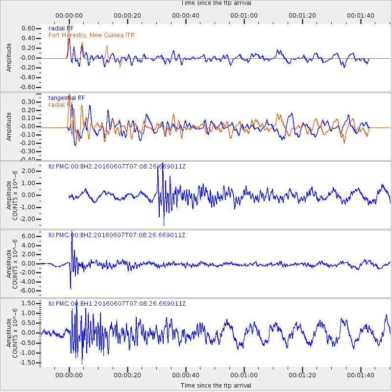
Signal To Noise
| Channel | StoN | STA | LTA |
| IU:PMG:00:BHZ:20160607T07:08:26.669011Z | 8.833337 | 2.006759E-6 | 2.2718017E-7 |
| IU:PMG:00:BH1:20160607T07:08:26.669011Z | 4.381466 | 6.6347314E-7 | 1.514272E-7 |
| IU:PMG:00:BH2:20160607T07:08:26.669011Z | 4.7460647 | 1.1218349E-6 | 2.363716E-7 |
| Arrivals |
| Ps | |
| PpPs | |
| PsPs/PpSs | |


