You are here: Home > Network List > CI - Caltech Regional Seismic Network Stations List
> Station MPP McPhearson Peak > Earthquake Result Viewer
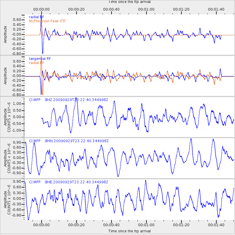
MPP McPhearson Peak - Earthquake Result Viewer
*The percent match for this event was below the threshold and hence no stack was calculated.
| Earthquake location: |
Tonga Islands |
| Earthquake latitude/longitude: |
-15.6/-173.4 |
| Earthquake time(UTC): |
2009/09/29 (272) 23:11:51 GMT |
| Earthquake Depth: |
10 km |
| Earthquake Magnitude: |
5.5 MB |
| Earthquake Catalog/Contributor: |
WHDF/NEIC |
|
| Network: |
CI Caltech Regional Seismic Network |
| Station: |
MPP McPhearson Peak |
| Lat/Lon: |
34.89 N/119.81 W |
| Elevation: |
1739 m |
|
| Distance: |
71.4 deg |
| Az: |
44.235 deg |
| Baz: |
234.856 deg |
| Ray Param: |
$rayparam |
*The percent match for this event was below the threshold and hence was not used in the summary stack. |
|
| Radial Match: |
39.53794 % |
| Radial Bump: |
400 |
| Transverse Match: |
61.142406 % |
| Transverse Bump: |
400 |
| SOD ConfigId: |
2622 |
| Insert Time: |
2010-02-26 02:05:35.559 +0000 |
| GWidth: |
2.5 |
| Max Bumps: |
400 |
| Tol: |
0.001 |
|
Signal To Noise
| Channel | StoN | STA | LTA |
| CI:MPP: :BHN:20090929T23:22:40.344998Z | 1.0194963 | 7.200053E-7 | 7.0623634E-7 |
| CI:MPP: :BHE:20090929T23:22:40.344998Z | 0.49181455 | 3.5628375E-7 | 7.24427E-7 |
| CI:MPP: :BHZ:20090929T23:22:40.344998Z | 1.0281917 | 5.9017617E-7 | 5.739943E-7 |
| Arrivals |
| Ps | |
| PpPs | |
| PsPs/PpSs | |


