You are here: Home > Network List > TA - USArray Transportable Network (new EarthScope stations) Stations List
> Station A17A Triple J Farms, Joplin, MT, USA > Earthquake Result Viewer
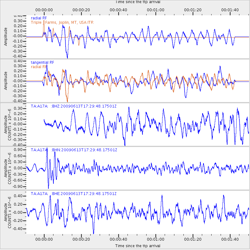
A17A Triple J Farms, Joplin, MT, USA - Earthquake Result Viewer
*The percent match for this event was below the threshold and hence no stack was calculated.
| Earthquake location: |
Eastern Kazakhstan |
| Earthquake latitude/longitude: |
44.7/78.9 |
| Earthquake time(UTC): |
2009/06/13 (164) 17:17:38 GMT |
| Earthquake Depth: |
14 km |
| Earthquake Magnitude: |
5.8 MB, 5.1 MS, 5.4 MW, 5.4 MW |
| Earthquake Catalog/Contributor: |
WHDF/NEIC |
|
| Network: |
TA USArray Transportable Network (new EarthScope stations) |
| Station: |
A17A Triple J Farms, Joplin, MT, USA |
| Lat/Lon: |
48.94 N/110.70 W |
| Elevation: |
973 m |
|
| Distance: |
86.3 deg |
| Az: |
6.301 deg |
| Baz: |
353.184 deg |
| Ray Param: |
$rayparam |
*The percent match for this event was below the threshold and hence was not used in the summary stack. |
|
| Radial Match: |
53.78799 % |
| Radial Bump: |
383 |
| Transverse Match: |
59.92644 % |
| Transverse Bump: |
400 |
| SOD ConfigId: |
2648 |
| Insert Time: |
2010-03-06 12:52:11.863 +0000 |
| GWidth: |
2.5 |
| Max Bumps: |
400 |
| Tol: |
0.001 |
|
Signal To Noise
| Channel | StoN | STA | LTA |
| TA:A17A: :BHN:20090613T17:29:48.17501Z | 5.932097 | 4.3097273E-7 | 7.265099E-8 |
| TA:A17A: :BHE:20090613T17:29:48.17501Z | 2.9246893 | 2.2475095E-7 | 7.68461E-8 |
| TA:A17A: :BHZ:20090613T17:29:48.17501Z | 1.6050769 | 1.5893363E-7 | 9.901932E-8 |
| Arrivals |
| Ps | |
| PpPs | |
| PsPs/PpSs | |


