You are here: Home > Network List > IW - Intermountain West Stations List
> Station MOOW Moose Ponds, Wyoming, USA > Earthquake Result Viewer
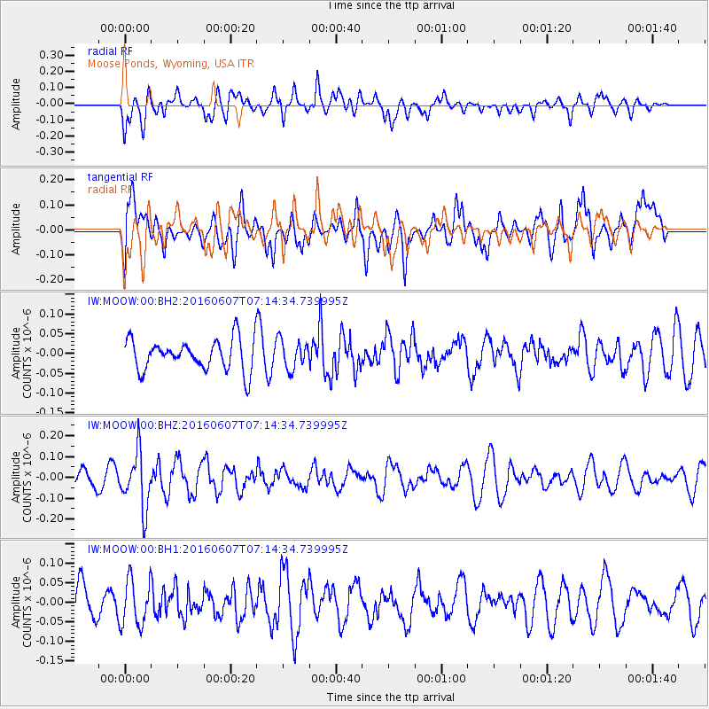
MOOW Moose Ponds, Wyoming, USA - Earthquake Result Viewer
*The percent match for this event was below the threshold and hence no stack was calculated.
| Earthquake location: |
South Of Fiji Islands |
| Earthquake latitude/longitude: |
-23.7/-179.9 |
| Earthquake time(UTC): |
2016/06/07 (159) 07:02:52 GMT |
| Earthquake Depth: |
523 km |
| Earthquake Magnitude: |
5.5 MB |
| Earthquake Catalog/Contributor: |
NEIC PDE/NEIC COMCAT |
|
| Network: |
IW Intermountain West |
| Station: |
MOOW Moose Ponds, Wyoming, USA |
| Lat/Lon: |
43.75 N/110.74 W |
| Elevation: |
2128 m |
|
| Distance: |
92.2 deg |
| Az: |
42.651 deg |
| Baz: |
239.014 deg |
| Ray Param: |
$rayparam |
*The percent match for this event was below the threshold and hence was not used in the summary stack. |
|
| Radial Match: |
55.117916 % |
| Radial Bump: |
400 |
| Transverse Match: |
52.393612 % |
| Transverse Bump: |
400 |
| SOD ConfigId: |
1609551 |
| Insert Time: |
2016-06-22 15:12:09.676 +0000 |
| GWidth: |
2.5 |
| Max Bumps: |
400 |
| Tol: |
0.001 |
|
Signal To Noise
| Channel | StoN | STA | LTA |
| IW:MOOW:00:BHZ:20160607T07:14:34.739995Z | 2.9728565 | 1.3777775E-7 | 4.6345235E-8 |
| IW:MOOW:00:BH1:20160607T07:14:34.739995Z | 1.2653296 | 5.936909E-8 | 4.6919865E-8 |
| IW:MOOW:00:BH2:20160607T07:14:34.739995Z | 0.9122005 | 3.6069476E-8 | 3.954117E-8 |
| Arrivals |
| Ps | |
| PpPs | |
| PsPs/PpSs | |


